
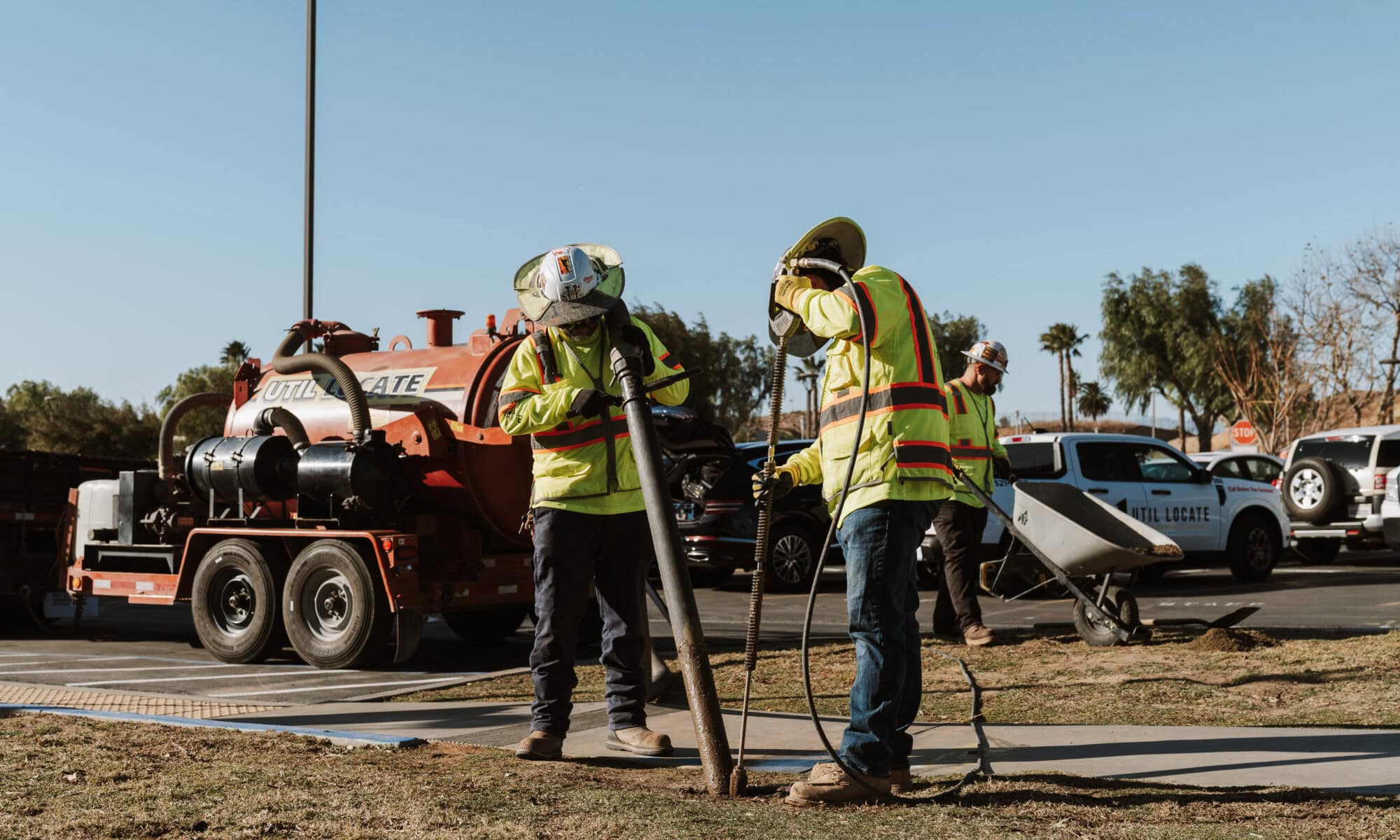
Municipal rights-of-way hold layered water, sewer, electric, gas, telecom, and fiber lines that all need protection during construction. Hydro excavation for municipal utility projects gives public works teams a way to expose those lines without service interruptions, safety incidents, or schedule slips. Pressurized water paired with vacuum recovery lets crews see depth, material, and conflicts before any blade touches soil. The method works alongside underground utility locating and ground-penetrating radar rather than replacing either one.
Below, you will find how the process works, where it fits across project phases, which municipal jobs gain the most from it, and how crews plan, protect, and document each dig. Util-Locate has performed this work across Southern California and Arizona since 2001.
Key Takeaways
- Hydro excavation uses pressurized water and vacuum recovery to expose utilities more precisely than mechanical digging
- FHWA research shows subsurface utility engineering returns $4.62 for every $1.00 invested across highway projects
- PHMSA warns that pipeline markers show only general location and do not indicate precise depth or alignment
- Visual utility confirmation reduces strike risks during water main repairs, storm drain work, and roadway reconstruction
- OSHA excavation safety requirements remain necessary even when using non-destructive hydro excavation methods
Hydro Excavation for Municipal Utility Projects Explained
Hydro excavation is a non-destructive digging method. Pressurized water loosens soil while a vacuum system lifts the material away, so buried lines never meet the blade contact that damages them during backhoe or trenching work. Utility potholing and vacuum excavation create small access points where crews inspect pipe diameter, material type, and exact depth.
Technicians direct water into the excavation zone to break up compacted soil, then a high-power vacuum transfers the loosened material into a debris tank. Operators work within inches of live lines without mechanical impact that could crack pipes or sever cables.
Hydro Excavation Compared With Air Vacuum Excavation
Both methods use vacuum recovery. The difference is the medium that breaks up the soil, and site conditions decide which one fits. Choosing between hydro and air excavation depends on soil type, weather, and the utilities being exposed.
| Factor | Hydro (water) excavation | Air vacuum excavation |
|---|---|---|
| Soil-loosening medium | Pressurized water | Compressed air |
| Strongest in | Dense clay, compacted urban fill | Freezing weather, sandy or loose soil |
| Spoil produced | Wet slurry needing containment | Dry soil often reusable as backfill |
| Speed on hard ground | Faster | Slower |
| Watch-outs | Slurry handling, moisture-sensitive lines | Reduced cutting power in hard-packed ground |
Vacuum Methods Compared With Mechanical and Hand Digging
Vacuum excavation removes soil more precisely than a backhoe in congested corridors, because mechanical equipment cannot adjust blade depth once the operator commits to a scoop. Smaller excavation windows also limit traffic disruption, restoration work, and dust. The trade-off is throughput, since vacuum methods take longer per cubic yard in open areas with high soil volume.
| Method | Precision near live lines | Volume rate | Typical municipal use |
|---|---|---|---|
| Hydro or air vacuum excavation | High, no blade contact | Moderate | Potholing, tie-ins, crossings |
| Mechanical excavation | Low once the bucket commits | High | Bulk trenching away from known lines |
| Hand digging | High but slow | Low | Final inches around an exposed line |
Core Components of a Hydro Excavation Setup
Water pressure adjusts to soil density and to the sensitivity of nearby infrastructure such as fiber optic cable, and operators reduce pressure in the final inches above a utility surface. A vacuum system moves loosened material into a debris tank mounted on the truck, which keeps spoil out of storm drains. Tank capacity sets how long a crew works before hauling material to a disposal site.
Hydro Excavation for Municipal Utility Projects Reduces Strike Risk and Downtime
Municipal work often lands where several underground systems overlap inside a narrow right-of-way. Water mains cross beneath sewer lines, and fiber shares trenches with electric conduit. Hydro excavation supplies the visual proof that as-built drawings and locating alone cannot guarantee.
Private underground utility locating services identify probable utility paths, but only physical exposure confirms exact depth, material condition, and spatial conflicts. That verification cuts change orders and protects the service continuity public works directors answer for.
Visual Confirmation Cuts Utility Strike and Disruption Risk
Crews confirm a line’s presence, alignment, size, and condition instead of trusting decades-old drawings. Field verification matters most at complex intersections where several utility owners share corridor space, since exposing one line often reveals a conflict that never appeared on the construction plans. Accurate subsurface data prevents damage that would interrupt water service, sever fiber, or trigger a gas release.
Safety Gains Over Mechanical Excavation
Mechanical excavation near hidden utilities creates risk because operators have no visual information once soil removal starts. Hydro excavation lowers utility-damage risk during exposure, and workers face fewer unknowns when infrastructure is uncovered before hand tools or equipment continue. It does not remove trenching duties, since OSHA still requires cave-in protection, safe access and exit points, and regular trench inspection.
Schedule and Budget Control From Early Verification
An FHWA and Purdue University study found subsurface utility engineering returned $4.62 for every $1.00 spent across 71 projects in Virginia, North Carolina, Texas, and Ohio, representing construction value above $1 billion. Savings came from fewer utility relocations, fewer change orders, and conflicts caught during design rather than construction.
Verified depth and material data let engineers refine trench alignment, adjust pole placement, and sequence relocations before mobilization. Early field verification prevents rework, repair costs, and the service interruptions that damage a project’s reputation.
Project Stages Where Hydro Excavation Delivers Value
The method fits four phases: pre-design investigation, pre-construction verification, active construction support, and emergency response. Timing changes the payoff. Early verification reduces redesign cost, while late-stage potholing prevents damage during active trenching.
Public works teams fold the method into a workflow that starts with utility locating and record review, then confirm critical conflicts before contracts close.
| Project stage | What crews confirm | Why it pays off |
|---|---|---|
| Pre-design investigation | Depth and horizontal alignment at design control points | Design avoids conflicts instead of relocating them later |
| Pre-construction verification | Crossings, tie-ins, and clearances before mobilization | Contracts and sequencing reflect real field conditions |
| Active construction | Utility positions ahead of trenching and boring | Trades share the corridor without strikes |
| Emergency response | The damaged section and adjacent lines | Repairs proceed without causing a second failure |
Pre-Design and Site Investigation Potholing
Potholing uses high-power vacuum suction to excavate soil during site investigation. Subsurface utility engineering, promoted by FHWA since 1987, applies locating and record review first to narrow probable positions, then confirms them physically. Pre-design potholing helps engineers verify depth and alignment at the points that drive design, such as intersection improvements, storm drain installations, and roadway widening.
Potholing and Daylighting Before Construction
Daylighting exposes a buried utility for visual confirmation of location, depth, and material condition. Potholing is the controlled excavation that verifies size, depth, and material before work approaches sensitive infrastructure. Municipal teams prioritize it at utility crossings, service tie-ins, alignment bends, and corridors with conflicting records. Calling Arizona 811 before digging covers public utilities, but it does not close private facility gaps or confirm precise depth.
Active Construction and Emergency Repair Support
Exposed utility information guides sequencing when several trades need the same trench corridor. Water main repair benefits from vacuum methods that expose the damaged section without disturbing adjacent sewer or gas lines. Storm drain replacement pairs hydro excavation with CCTV drain surveys to verify pipe condition and connection points. Emergency breaks need fast access, and vacuum methods deliver it while limiting collateral damage.
Municipal Use Cases That Benefit From Hydro Excavation
Water, sewer, storm drainage, roadway, and energy systems share congested underground space. Each utility type presents a different exposure challenge based on pipe material, operating pressure, and proximity to neighboring lines, so crews adjust water pressure and vacuum settings to match.
Knowing which project types gain the most from vacuum excavation helps a municipality direct its investigation budget toward high-risk work.
| Municipal work | Lines usually in play | What exposure confirms |
|---|---|---|
| Water and sewer main repair | Pressurized water, gravity sewer, gas, electric | Pipe material, depth, and joint condition before cutting |
| Storm drain and culvert work | Storm lines, laterals, roadway drainage | Connection points and structural condition |
| Roadway and streetscape upgrades | Water services, drainage structures, telecom | Clearances before surface removal and grading |
| Signal, lighting, and fiber conduit | Electric, telecom, legacy conduit | Safe trench paths inside occupied corridors |
| Renewable energy and EV infrastructure | Electrical distribution, undocumented site utilities | Tie-in points and foundation clearances |
Water, Sewer, and Storm Drain Projects
Utility locating before sewer line repairs identifies probable pipe positions, and hydro excavation confirms them before cutting or replacement starts. Storm drain, culvert, and inspected pipeline work combines video inspection with physical exposure to verify connection points and structural condition. Water main breaks demand rapid access while gas, electric, and communication lines in the same trench stay intact.
Roadway and Infrastructure Upgrades
Reconstruction, sidewalk replacement, curb installation, and streetscape work all require exposing utilities before surface removal and grading. Relocations often move water services, drainage structures, and communication lines to make room for wider lanes. Vacuum excavation minimizes traffic disruption during roadworks by shrinking excavation footprints and restoration requirements.
Renewable Energy and Utility Relocation Projects
Solar field trenching runs electrical infrastructure across large sites where underground utilities may be poorly documented. Battery storage foundations need subsurface verification before excavation for structural supports. Interconnections require precise exposure of existing electrical infrastructure before tapping distribution systems, and EV charging installations place new conduit in parking areas and street corridors that already carry utilities.
Planning Decisions Behind Municipal Hydro Excavation
Planning starts with utility locating, record review, and risk assessment. Not every point on a project needs physical exposure, but high-consequence locations do. A clear decision framework helps directors spend investigation budgets where a strike would halt construction or cut service to residents.
Site conditions also govern timing. Traffic control, spoil handling, environmental permits, and utility owner notifications must line up before vacuum excavation starts inside a public right-of-way.
Integrating Utility Locating, GPR, and Hydro Excavation
Electromagnetic locating reaches 97% accuracy up to 13 feet deep in favorable conditions, without disturbing pavement or soil. Ground-penetrating radar adds coverage of non-metallic utilities and maps subsurface layers that affect excavation planning. Teams review locating data, as-built drawings, and GPR results together, then select pothole locations where visual confirmation returns the most value.
Conditions That Put Hydro Excavation First
Congested utility corridors, high-pressure gas lines, primary electrical feeders, and fiber backbones justify non-destructive methods on their own. So do outdated as-built records, conflicting utility owner data, and suspected abandoned infrastructure. Trenchless installations still need potholing to verify clearances for horizontal boring, and emergency repairs need speed and utility protection at the same time.
Site Preparation and Safety Measures
Crews coordinate traffic control, spoil handling, environmental controls, site access, lane closures, and restoration before work begins, and contacting the local One-Call center remains mandatory. OSHA requires trench inspection before each shift and safe entry and exit for any excavation deeper than four feet. Keeping spoil and equipment back from trench edges, managing standing water, and checking atmospheric hazards belong on every excavation checklist.
Documentation and Compliance Gains From Field Verification
Field-verified positions produce better project records than design assumptions or aging as-built drawings. Agencies use exposed utility data to update master utility maps, adjust design plans, and build documentation that later projects depend on. Utility mapping services convert field observations into CAD drawings, GIS data, and KML files that engineers open during planning.
Documented verification also eases compliance with federal, state, and local requirements, and projects using federal highway funds or grant support often require subsurface utility engineering. Sound records reduce legal exposure by showing that reasonable investigation preceded excavation.
Utility Mapping and CAD Deliverables
Field crews record depth, pipe material, diameter, condition, and horizontal position relative to survey benchmarks or street centerlines. Those observations become CAD files, KML formats, and record drawings that overlay verified positions onto base maps showing streets, property lines, and surface features. Digital records build institutional knowledge instead of scattered paper as-builts.
Visual Confirmation Improves Records and Conflict Resolution
Exposure resolves disagreements between as-builts filed by different utility owners or construction eras, and it reveals materials, depths, and alignments that drifted from design intent over decades. Photographic documentation supports design adjustments, change order negotiation, and dispute resolution. That evidence moves a project from change-driven delay toward predictable execution.
CCTV Pipe Inspection for Sewer and Drainage Verification
CCTV pipe inspection verifies internal condition, joint alignment, and structural integrity before sewer or storm drain replacement, flagging root intrusion, collapse, offset joints, and blockages. Paired with external exposure at key points, video gives a complete condition assessment, helps prioritize segments inside capital improvement programs, and documents conditions before and after construction.
Common Municipal Excavation Risks and Their Controls
Municipal excavation carries utility strikes, trench collapses, service interruptions, traffic disruption, and environmental releases. OSHA identifies cave-ins as the greatest threat to worker life in trenching and excavation work, and PHMSA treats accidental excavation damage as one of the greatest challenges to safe pipeline operation.
Damage reaches gas, electric, water, sewer, telecom, and private facilities, and the resulting interruptions create public complaints, emergency response costs, and political accountability.
| Risk | Consequence | Control |
|---|---|---|
| Utility strike | Outages, injuries, emergency repair costs | Locate first, then expose with vacuum methods before trenching |
| Trench cave-in | Primary worker fatality risk in trenching | Shoring or sloping, spoil setback, inspection each shift |
| Service interruption | Public complaints, business and hospital impact | Verified depth and alignment before cutting or tapping |
| Traffic disruption | Extended lane closures and restoration | Smaller excavation footprints and staged closures |
| Environmental release | Slurry or spoil entering storm drains | Contained debris tanks and permitted disposal |
Utility Strike and Public Impact Risks
Strike prevention starts by removing blade contact between equipment and buried infrastructure. Hydro excavation lifts soil without the cutting forces that sever cable, crack pipe, or puncture pressurized lines, so gas, electric, water, sewer, telecom, and fiber incidents all decline. Disruption from a strike usually exceeds the original excavation impact, since emergency repair adds closures and restoration work. Smaller excavation footprints shorten that exposure and speed project completion.
Remaining Safety and Environmental Risks
OSHA trenching controls apply regardless of the method used to expose a utility. Safe access and egress, spoil placement away from trench edges, standing water management, and cave-in protection stay in force. Standing water creates drowning hazards and weakens soil near trench walls, and ladders or ramps must let workers exit quickly. Excavation risk management remains a duty separate from utility protection.
Old Records and Unknown Utilities
Pipeline markers show general location or right-of-way only, not precise position or depth of burial. The 811 One-Call system does not cover private installations on commercial properties, campuses, or industrial sites. Municipal corridors mix public infrastructure, private facilities, abandoned lines, and construction from several eras, and old drawings often record design intent rather than what crews actually built.
Hydro Excavation’s Role in Safer Municipal Utility Delivery
Municipal infrastructure work balances construction pace against protection of the lines communities depend on. Hydro excavation turns subsurface uncertainty into confirmed field data before equipment mobilizes.
The FHWA cost-benefit research shows that early utility investigation protects budget and schedule against mid-construction surprises. Agencies that pair hydro excavation with utility locating, ground-penetrating radar, and mapping build lasting knowledge of what sits under their streets, which lowers service interruptions and supports compliance across water, sewer, roadway, and energy programs.
Schedule Hydro Excavation With Util-Locate
Util-Locate has supported municipal utility projects across Southern California and Arizona since 2001, combining utility locating, ground-penetrating radar, hydro excavation, CCTV pipe inspection, and ASCE-referenced mapping. Certified technicians locate buried lines up to 13 feet deep with 97% accuracy and deliver findings in PDF, CAD, and KML formats your engineers can use right away.
Call (888) 885-6228 to walk through your corridor with a specialist, or request a quote and we will scope the potholing plan around your schedule. 24/7 emergency service is available when a break cannot wait for business hours.
Frequently Asked Questions
Q1. How much does hydro excavation cost for a municipal project?
Pricing depends on the number of potholes, target depth, soil conditions, surface type, traffic control, permits, and spoil disposal. Most municipal work is quoted per pothole or as a day rate covering the truck, water, and crew. Deep exposures, hard surfaces, and congested corridors raise the per-hole figure. FHWA research puts that spend in context, showing $4.62 returned for every $1.00 invested in subsurface utility engineering. A site-specific quote remains the only reliable number.
Q2. How deep can hydro excavation expose buried utilities?
Most municipal potholes reach 3 to 8 feet, which covers typical water, sewer, gas, and telecom depths. Boom and hose extensions take crews deeper when a project calls for it, though tank capacity and spoil handling become the limiting factors. Locating results set the target depth before the truck arrives, and electromagnetic sensors with GPR support reach 97% accuracy up to 13 feet in favorable ground. Exposures below roughly five feet also bring trench protection requirements into play.
Q3. Does a municipal project still need hydro excavation after calling 811?
Yes, because the two serve different purposes. The 811 One-Call system marks member-owned public utilities and is required before excavation, but it does not confirm depth, and it does not cover private lines on campuses, commercial sites, or industrial properties. PHMSA notes that pipeline markers show only general location or right-of-way. Hydro excavation supplies the physical confirmation of depth, material, and alignment that marks alone cannot give.
Q4. How long does a single hydro excavation pothole take?
A straightforward pothole usually takes 30 to 90 minutes from setup to backfill. Depth, soil density, and surface type drive that range, since coring asphalt or concrete adds time at both ends. A crew commonly completes several potholes in one shift when the locations sit close together. Traffic control, permits, and utility owner notification often shape the schedule more than the digging itself. Most surfaces are restored the same day.
Q5. What documentation do municipal teams receive after hydro excavation?
Crews record measured depth to the utility surface, pipe material, diameter, condition, and horizontal position tied to survey control or street centerline, along with site photographs. Those observations are delivered as field reports and converted into CAD drawings, KML files, and GIS-ready data. Agencies use the results to update master utility maps and adjust design plans before construction. The same records support change order discussions and dispute resolution later in the project.
