Underground Utility Locating: How Does the Type of Utility Being Located Affect the Locating Process?

underground utility locating services in California

Beneath the surface of every construction project lies a complex web of utilities, and understanding how the type of utility influences the locating process is crucial for a seamless and secure excavation journey.

Whether it’s power cables, sewer lines, or water pipes, each utility demands a tailored approach. Learn more about underground utility locating services in California and explore the impact of utility types on equipment selection, safety measures, and regulatory adherence.

Understand the Utility Tapestry

The first step in effective utility locating is recognizing the diverse range of utilities present beneath the surface.

From power and gas lines to sewer and water pipes, each utility requires specialized attention. Utility locators play a pivotal role in deciphering this tapestry, employing advanced techniques to pinpoint the exact location of these vital components.

Equipment Selection: Tailor Tools to Utilities

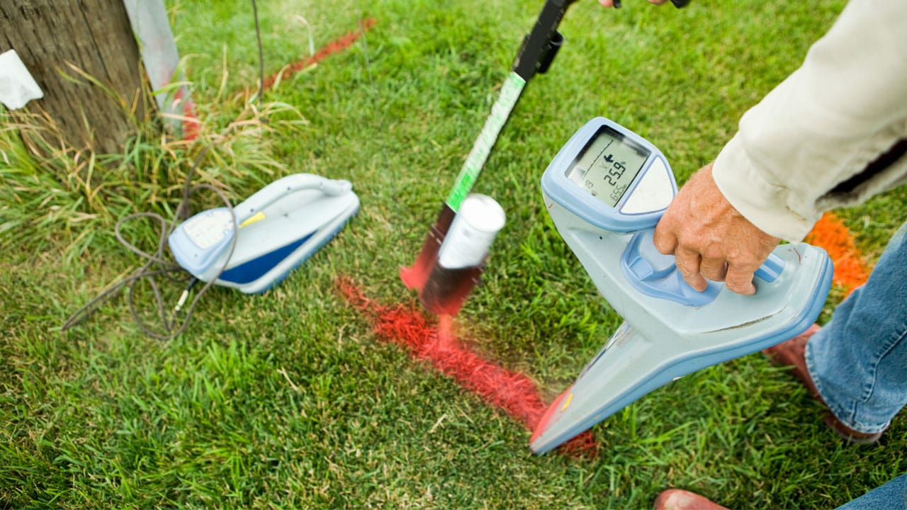
Different utilities call for different tools. Metallic pipes and power cables, for instance, are efficiently traced using electromagnetic locators, which detect the magnetic fields generated by these materials.

On the other hand, non-metallic utilities, such as plastic pipes, pose a unique challenge. Ground-penetrating radar (GPR) emerges as the hero in such scenarios, using radar pulses to identify variations in subsurface materials and locate non-metallic utilities with precision.

Safety Considerations: Mitigate Risks for All Utilities

Safety is paramount in any construction endeavor, and utility locating is no exception. The type of utility being located significantly influences safety measures.

For gas lines, the risk of leaks underscores the importance of meticulous locating to prevent potentially hazardous situations. Similarly, electric cables demand careful handling to avert electrical hazards during the locating process.

Regulatory Compliance: Navigate the Legal Landscape

Navigating the legal landscape of underground utility locating requires a thorough understanding of regulatory compliance.

Different types of utilities may be subject to varying regulations, and adherence is non-negotiable. Utility companies, construction projects, and private utility locators must align with local, state, and federal guidelines to ensure a seamless and lawful process.

Challenges and Solutions: Overcome Diversity in Utility Locating

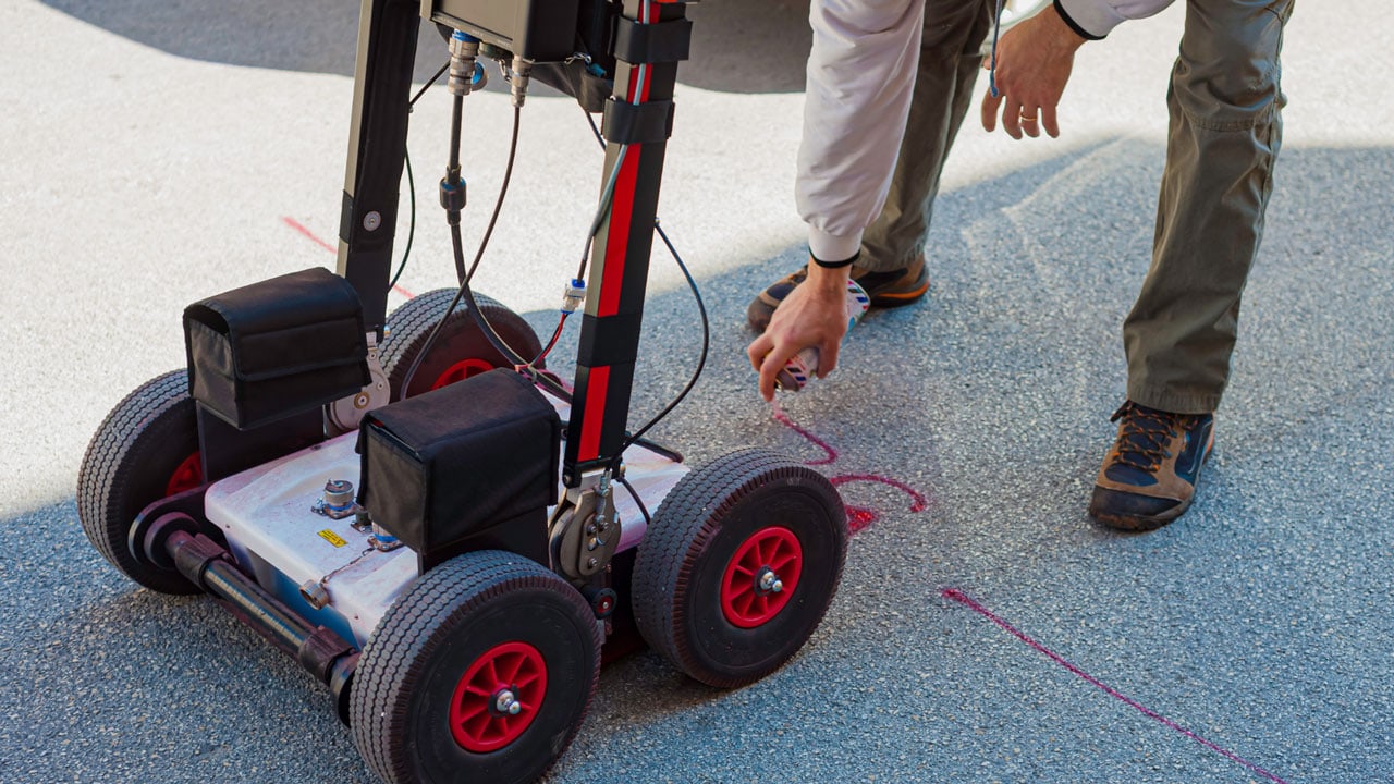
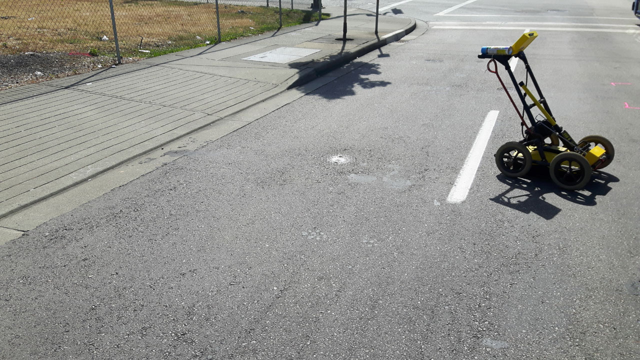
The diversity of utilities introduces challenges, but with challenges come opportunities for innovation. Advanced technologies, including GPR services and sophisticated electromagnetic locators, enable utility locators to overcome the hurdles posed by various utility types.

Real-time data collection, 3D mapping, and accurate depth determination contribute to a comprehensive understanding of the underground landscape.

Diverse Soil Conditions: Unravel the Underground Puzzle

As we delve into the complexities of utility locating, it’s essential to address the role of soil conditions in this intricate process. The type of soil can significantly impact the accuracy of locating utilities.

Loose, sandy soils allow for better GPR penetration, offering clearer images of subsurface structures. In contrast, dense, clay-rich soils may pose challenges, scattering radar signals and requiring additional expertise in interpretation.

The Ground Surface Conundrum: Challenges and Solutions

The ground surface isn’t uniform, and variations introduce challenges during utility locating. Concrete structures, asphalt, and even natural materials like rocks can impede signals, affecting the accuracy of the GPR method.

Understanding these challenges is the first step, and advanced GPR scanning services play a crucial role in mitigating issues by providing detailed insights into subsurface anomalies.

Moisture Content Matters: Navigate Below the Water Table

Moisture content in the soil is a critical factor influencing GPR accuracy. High moisture levels can limit signal penetration, leading to less detailed scans.

Identifying these variations in moisture content is paramount, especially when dealing with underground utility lines in areas prone to waterlogging. GPR services, equipped to handle diverse soil conditions, offer a reliable solution for accurate utility mapping.

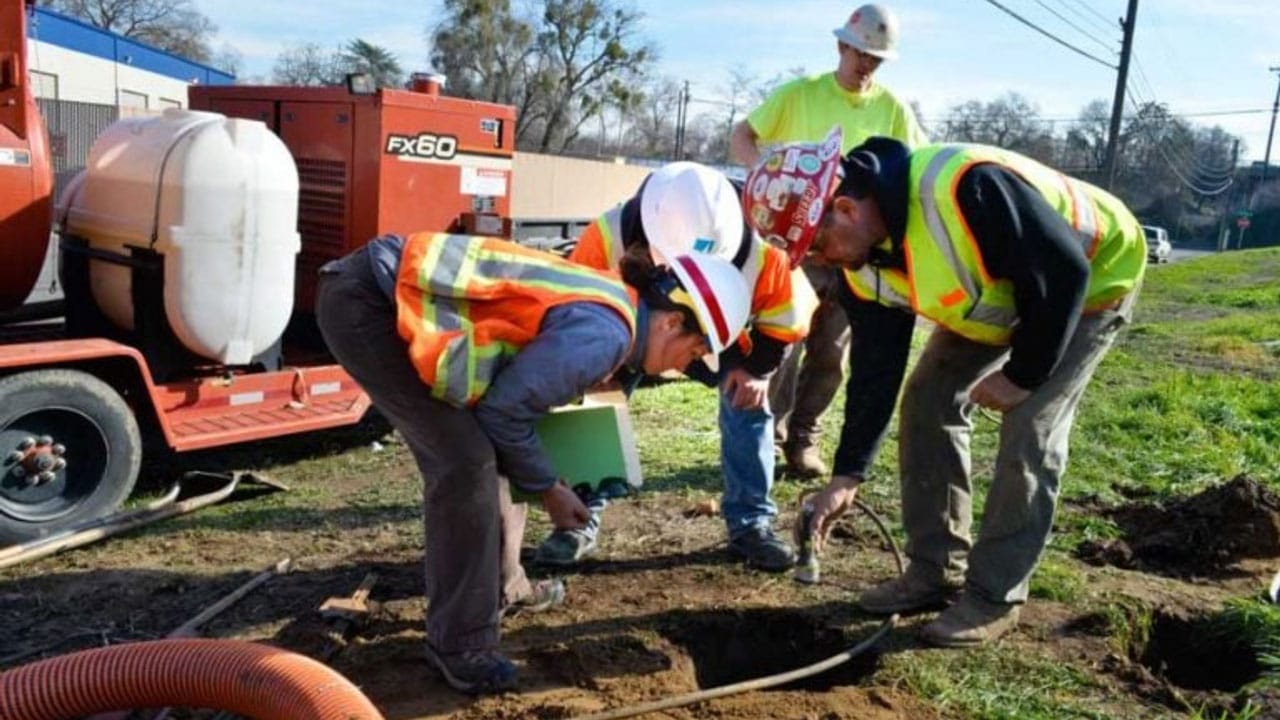
Utility Lines and Potential Hazards: Ensure Worker Safety

Construction workers face potential hazards when dealing with underground utility locating. Understanding the type of soils and the presence of various utilities is crucial for minimizing risks.

Accurate detection of power cables, gas lines, and other hidden utilities prevents accidents and ensures a safe working environment. Investing in private utility locators equipped with the latest technology is an investment in the safety of both workers and the public.

Subsurface Structures: Decode the Hidden Layers

The accuracy of utility locating services depends on decoding the layers beneath the surface. Subsurface structures, including buried pipes, electrical conduits, and sewer lines, demand a meticulous approach.

GPR services excel in offering a detailed analysis of these subsurface elements, providing valuable information for construction planning, infrastructure visualization, and risk mitigation.

Innovations in Utility Locating: Meeti the Challenges Head-On

Addressing the challenges posed by diverse soil conditions, ground surfaces, moisture content, and potential hazards requires continuous innovation. Ground-penetrating radar, with its wide range and adaptability, emerges as a versatile solution.

Modern GPR systems can penetrate various soil types, deliver high-resolution imaging, and provide accurate depth information, making them indispensable for underground utility mapping

Depth of Penetration: Unravel the Layers Below

The depth of penetration is a critical consideration in utility locating, influencing the effectiveness of GPR in revealing subsurface structures. Different soil types and moisture content impact how deep radar signals can penetrate.

Private utility locators, equipped with advanced GPR systems, assess these factors meticulously, providing a nuanced understanding of subsurface layers and ensuring accurate mapping of utilities.

Empower Your Projects with Precision – Contact Util-Locate Today!

Start your project with precision and reliability. Util-Locate us your trusted partner in comprehensive utility locating services in Southern California.

Whether you’re gearing up for a construction project, planning infrastructure development, or simply need a detailed understanding of subsurface features, Util-Locate brings unparalleled expertise to the table.

Our advanced technologies, including Ground Penetrating Radar (GPR) services and state-of-the-art utility potholing, ensure accurate mapping of utilities, reducing risks and preventing costly surprises.

Don’t let uncertainties below the surface impact your project’s success. Contact Util-Locate today at 866-638-1075 and unlock the full potential of your endeavors. Precision, safety, and efficiency are not just promises; they are the foundations on which Util-Locate builds success.

Private Utility Locating: How Does Surface Area Impact Utility Locating?

Private utility locating

Surface area can have a significant impact on private utility locating efforts. Learn how surface area affects the scope of work, scanning efficiency, utility density, access constraints, and overall project costs. Contact Util-Locate today for reliable utility locating services in Southern California!

Private utility locating, a critical aspect of construction and development, becomes more nuanced when the surface area comes into play. In this comprehensive guide, we delve into the intricate relationship between surface area and utility locating, unraveling the complexities and offering valuable insights for a successful project.

Surface Area Dynamics in Utility Locating

The surface area of a construction site plays a critical role in determining the scope, efficiency, and accuracy of utility locating. A wide range of factors is influenced by the surface area, making it a key consideration for any excavation project.

  • Wide Range of Utilities – A sprawling surface area often corresponds to a diverse underground utility network. From electric cables to water lines, the sheer expanse demands a tailored approach to locate and map these intricate systems accurately.
  • Impact on Excavation Project Costs – The cost of a utility locating project is significantly affected by the surface area. Larger areas may involve more utilities and complexities, impacting the overall budget. Understanding these cost implications is crucial for project planning and financial management.
  • Ground Penetrating Radar (GPR) in Varying Soil Conditions – Different soil conditions across the surface area pose a challenge for utility locating. The effectiveness of Ground Penetrating Radar (GPR) can vary based on soil composition, moisture content, and other geological factors. Adaptable strategies are essential for accurate results in diverse terrains.
  • Private Utility Locator Expertise – Private utility locators must navigate the surface area to provide accurate information about the types of utilities present. Their expertise becomes increasingly vital as the project’s scale and complexity grow.
  • Infrastructure Visualization Services – Advancements in technology, such as 3D infrastructure visualization services, offer a holistic view of the underground landscape. Surface area influences the application and effectiveness of these technologies, aiding in precise utility mapping.

Navigate Challenges with 5 Strategic Solutions

  1. Accurate Location of Utilities – Understanding the impact of surface area allows for strategic planning to ensure the accurate location of utilities. This includes employing advanced equipment like GPR and private utility locators that can adapt to varying surface conditions.
  2. Regulatory Compliance – Large surface areas may entail compliance with diverse regulatory requirements. Navigating these regulations demands a meticulous approach to avoid delays and ensure adherence to safety standards.
  3. Time Efficiency in Utility Locating – The surface area directly correlates with the time required for utility locating. Efficient planning, streamlined processes, and the right technology can enhance time efficiency, minimizing delays in the overall project timeline.
  4. Structural and Subsurface Elements – Understanding the surface area helps anticipate the presence of structural and subsurface elements. This foresight is crucial for avoiding disruptions, ensuring the integrity of existing structures, and preventing potential hazards.
  5. Depth Measurement in Varying Terrains – The surface area impacts the depth measurement of utilities, especially in terrains with variations in elevation. Tailoring depth measurement techniques to the specific surface conditions is essential for precise results.

5 Best Practices for Effective Utility Locating

  1. Comprehensive Planning – Thoroughly assess the surface area to develop a comprehensive utility locating plan. Consider the types of utilities, soil conditions, and potential challenges posed by the landscape.
  2. Utilize Advanced Equipment – Invest in cutting-edge technologies, including GPR and private utility locating services, to navigate the complexities of different surface areas. These tools enhance accuracy and streamline the utility locating process.
  3. Follow Best Practices – Adhere to industry best practices for utility locating, considering the nuances of the surface area. This includes proper documentation, verification of utility types, and ongoing communication with project stakeholders.
  4. Prioritize Safety Measures – Large surface areas may introduce additional safety considerations. Prioritize safety measures, including clear utility markings, hazard identification, and compliance with safety regulations.
  5. Collaborate with Experts – Engage with experienced private utility locators who specialize in handling varying surface conditions. Their expertise and adaptability are invaluable for successful utility locating in diverse terrains.

The Role of Ground Conditions in Utility Locating Accuracy

Understanding the intricacies of ground conditions is central to enhancing the accuracy of utility locating services, especially when employing Ground Penetrating Radar (GPR).

The composition of the ground surface, soil conditions, and potential hazards all contribute to the efficacy of the utility locating process. Let’s explore further how ground conditions impact the accuracy of GPR and delve into additional considerations for achieving optimal results.

Diverse Soil Conditions and Their Impact

  • Moisture Content – Ground conditions vary in terms of moisture content, influencing the penetration depth of GPR signals. Moist soils may attenuate radar waves differently than dry soils, impacting the clarity and precision of underground utility imaging services.
  • Type of Soils – GPR performance is sensitive to the type of soil present. While sandy soils generally allow for better radar penetration, clayey soils or those with high conductivity can pose challenges. Understanding the soil composition is crucial for interpreting GPR results accurately.
  • Natural Materials – The presence of natural materials, such as rocks and vegetation, on the ground surface can affect GPR signals. These materials may scatter or absorb radar waves, potentially obscuring the detection of subsurface structures.

Navigate Potential Hazards in Ground Conditions

Underground Structures

Beyond utilities, the ground may house various subsurface structures, including foundations, pipelines, or historical artifacts. GPR’s ability to differentiate between utilities and other structures depends on the complexity of the ground conditions.

Hidden Utilities

The accuracy of GPR in locating hidden utilities is contingent on its ability to penetrate and reflect off these structures. Factors like ground disturbances, surface coverings, or dense materials above utilities can impact GPR’s effectiveness.

Geological Features

Geological features, such as changes in soil composition or the presence of bedrock, can introduce complexities. GPR may provide limited penetration in certain geological conditions, necessitating a tailored approach for accurate utility mapping.

Enhance Your Project’s Precision with Advanced Utility Locating Services from Util-Locate!

Begin on your construction project with confidence by partnering with Util-Locate, your trusted ally in precision utility locating in California. Our state-of-the-art Ground-Penetrating Radar (GPR) locating services ensure unparalleled accuracy, enabling you to navigate subsurface complexities seamlessly.

Don’t let hidden depths beneath the surface pose a challenge; instead, turn them into a strategic advantage. From private utilities to underground structures, our expertise empowers your project with comprehensive insights, promoting safety, compliance, and cost-effectiveness.

Choose Util-Locate for a transformative approach to utility mapping—because informed decisions begin with precise knowledge. Elevate your project’s success; contact us today at 866-638-1075!

5 Factors That Affect GPR Accuracy in Underground Utility Locating Service

underground utility locating services

Underground utility locating services are evolving, with technologies like Ground-Penetrating Radar (GPR) at the forefront. While GPR is a powerful tool, its accuracy hinges on various factors.

Let’s delve into the top five factors that influence the precision of GPR in the intricate world beneath our feet.

Five Factors Affecting GPR

The accuracy and effectiveness of GPR in underground utility locating services play an important role to minimize the risk of utility strikes and improve project outcomes.

1. Soil Conditions: The Foundation of Accuracy

The soil beneath our feet isn’t uniform. Variations in soil composition impact GPR signals differently. Soil conditions play a pivotal role in GPR accuracy. Dense soils, like clay, attenuate signals, limiting penetration depth.

Conversely, loose soils allow signals to travel deeper. Understanding the soil composition is essential for interpreting GPR results accurately.

2. Moisture Content: The Hidden Variable

Moisture content in the soil acts as a hidden variable in GPR accuracy. Water alters the dielectric properties of the soil, affecting signal penetration.

High moisture content reduces GPR penetration depth, making it challenging to detect utilities in waterlogged areas. GPR users must account for soil moisture to enhance the precision of their underground scans.

3. Ground Surface and Disturbances: Navigate the Terrain

The ground surface isn’t always smooth, and disturbances can impact GPR accuracy. Surface irregularities, pavement, and debris can cause signal reflections and diffractions.

Construction workers and equipment contribute to ground disturbances, creating challenges for GPR systems. Mitigating these factors ensures a clearer interpretation of the subsurface environment.

4. Type of Soils: Decode the Underground Puzzle

The type of soil is a critical factor influencing GPR accuracy. Different soils possess unique electromagnetic properties, impacting signal behavior.

Natural materials like sand allow for deeper signal penetration, while soils rich in minerals may attenuate signals. Understanding the type of soils present is essential for calibrating GPR equipment and interpreting results accurately.

5. Depth of Penetration: Beyond Surface-Level Insights

GPR’s capabilities vary with the depth of penetration required. Shallow applications offer high-resolution images of near-surface structures, suitable for tasks like locating buried utilities. However, as the depth increases, the resolution decreases.

GPR users must align their expectations with the depth of penetration required for their specific application to ensure optimal results.

GPR Scanning Services: Navigate Potential Hazards

While GPR is a versatile tool, users must be aware of its limitations. Concrete structures, dense geological features, or the presence of underground objects can impede GPR signals.

Additionally, hidden utilities, especially those made of non-conductive materials, may pose challenges. Collaborating with experienced GPR scanning services is crucial for overcoming potential hazards.

The Role of Utility Companies and Private Utility Locators

Utility companies play a pivotal role in ensuring the accuracy of GPR scans. Their records and collaboration facilitate a more comprehensive understanding of the subsurface environment. However, when dealing with private utilities, the expertise of private utility locators becomes indispensable.

Private locators specialize in identifying non-public utility lines, offering a more complete picture for GPR users.

Balance Wide Range and Accuracy: A GPR Conundrum

GPR systems offer a wide range of applications, from locating subsurface structures to identifying geological features.

However, this versatility comes with a challenge—balancing the wide range with accuracy. Users must understand the specific requirements of their project and tailor GPR settings accordingly to achieve optimal results.

Enhance GPR Accuracy for Construction Projects

Construction projects rely heavily on the accuracy of subsurface information. GPR scanning services ensure that projects proceed without encountering unexpected subsurface challenges.

By considering factors like soil conditions, moisture content, ground surface, type of soil, and depth of penetration, GPR users can enhance the accuracy of their scans and make informed decisions during construction planning.

Hidden Complexities: Subsurface Structures and Geological Features

Beyond the visible surface, a complex network of subsurface structures and geological features exists. GPR serves as a virtual explorer, offering insights into this hidden realm. However, the accuracy of GPR scans is influenced by the composition of these structures.

Denser materials, such as concrete, may hinder signal penetration, necessitating a nuanced approach when scanning areas with extensive subsurface structures.

Concrete Conundrum: Challenges in Urban Environments

Urban environments often pose unique challenges for GPR accuracy. The prevalence of concrete structures in city landscapes can impede signal penetration. Concrete reflects GPR signals, making it challenging to identify utilities or objects beneath.

Skilled interpretation and the use of complementary technologies become crucial in overcoming the concrete conundrum, ensuring accurate results in urban utility locating projects.

Utility Mapping Services: A Holistic Approach

While GPR plays a pivotal role, integrating it with utility mapping services provides a more holistic approach to subsurface exploration. Utility mapping involves comprehensive records search, on-site investigation, and collaboration with utility companies.

By combining GPR technology with utility mapping, a synergy is created, offering a multi-dimensional view of the underground landscape. This approach minimizes the impact of potential inaccuracies associated with individual methods.

Collaboration with Utility Companies: Leverage Existing Records

Utility companies are custodians of valuable information regarding the subsurface infrastructure. Collaboration with these entities is a strategic move to leverage existing records.

By tapping into utility company databases, GPR users gain access to critical data that enhances the accuracy of their scans. This collaboration ensures that utility mapping efforts align with real-world, on-the-ground information.

Private Utility Locators: Bridge the Information Gap

In scenarios involving private utilities, where records may not be as readily available, the expertise of private utility locators becomes invaluable.

These professionals specialize in identifying and marking private utility lines, contributing to a more comprehensive understanding of the subsurface environment. Their role is particularly crucial in projects where public utility records might not provide a complete picture.

Unveil the Depths with Certainty: Secure Your GPR Services Today!

Embark on your construction journey with confidence by leveraging our cutting-edge GPR scanning services. At Util-Locate, we specialize in precision-driven underground utility locating, employing advanced Ground-Penetrating Radar (GPR) technology.

Discover the hidden intricacies beneath the surface before breaking ground, ensuring safety, compliance, and cost-effectiveness. Our team of skilled professionals combines technology with expertise to deliver accurate results in diverse soil conditions and urban landscapes.

Don’t leave your project’s success to chance—partner with Util-Locate for unparalleled GPR services. Take the first step towards a secure and informed construction process—contact us now at 866-638-1075!

Professional Utility Locating Services in Los Angeles, CA: Discover the Hidden Depths Below the Surface Before Starting Any Subsurface Work

Los Angeles utility locating services

Before commencing any subsurface work, it’s crucial to thoroughly investigate and understand the hidden depths beneath the surface. Our Los Angeles utility locating services can help you navigate this process effectively to minimize risks, ensure regulatory compliance, and successfully execute subsurface work with confidence.

Los Angeles, with its vibrant landscape, is a hub of construction and development. Underneath the surface lies a complex network of utilities, making every excavation a potential challenge.

Before delving into any subsurface work, it’s crucial to understand the hidden depths. Professional utility locating services play an important role in ensuring a safe construction process.

The Importance of Utility Locating

Utility location is the first line of defense in any construction project. It involves identifying and mapping all site utilities, from sewer and storm drains to gas, water, communication, and electrical lines.

Util-Locate, with over two decades of experience, employs state-of-the-art techniques such as Ground Penetrating Radar (GPR) to provide accurate and comprehensive utility maps.

Navigate the Underground Maze

Underground utilities pose a significant challenge for construction projects. Without proper knowledge of their location and depth, excavation can lead to disastrous consequences. Private utilities, not always visible to the naked eye, are a particular concern.

Util-Locate’s expertise ensures that every inch of the subsurface is scrutinized, minimizing the risk of unexpected encounters during construction.

The Role of Utility Companies

Engaging private utility companies is a prudent step in the planning phase. These companies specialize in locating and mapping underground utilities.

However, it’s essential to choose a reliable partner. Util-Locate, recognized as one of the best utility locating companies in California, leads the way in subsurface investigations and damage prevention.

Private Utility Locators: Your Project’s Guardian

A private utility locator is your project’s guardian angel. While utility companies focus on public utilities, private locators like Util-Locate delve deeper, identifying even the most elusive private lines.

Their mastery of the underground world saves both time and resources, providing unmatched accuracy in utility location.

Utility Potholing: A Safer Approach

Traditional excavation methods can be risky, especially in built-up areas. Utility potholing, a newer technology, uses high-power vacuum suction systems to excavate soils during site investigations.

Util-Locate has embraced this safe excavation technique, employing vacuum excavation technology to meet client demands for damage prevention.

Understand the Properties of Materials

The success of any construction project lies in understanding the properties of materials beneath the surface. Util-Locate not only locates utility lines but also delves into the properties of materials.

Through techniques like GPR and electromagnetic locators, they provide insights into soil composition, identifying potential challenges before construction begins.

The Cost of Utility Strikes: More Than Just Dollars

The financial implications of utility strikes extend beyond repair costs. For utility suppliers, it means disruption to supplies, lost revenue, negative publicity, and customer service issues.

Contractors face project delays, cost implications, and damaged client relationships. Utility strikes can even pose risks to the safety of operators and the public.

5 Benefits of Underground Utility Mapping

The advantages of underground utility mapping extend beyond the immediate project phase. A comprehensive utility map offers five benefits, such as:

  1. Reduced Project Planning Downtime: Streamlining the planning process by having a clear understanding of the subsurface utilities.
  2. Minimized Risk: Identifying potential risks and challenges before excavation begins.
  3. Confidence in Project Execution: Providing the confidence to proceed with the project without surprises.
  4. Compliance with Safety Regulations: Ensuring that safety regulations and requirements are met throughout the construction process.
  5. Avoidance of the Unexpected: Anticipating and mitigating unexpected challenges during construction.

Advantages of GPR Scanning

GPR scanning emerges as a hero in utility locating. Util-Locate utilizes high-resolution GPR units to locate rebar, tension cables, conduits, voids, and other subsurface anomalies.

The benefits extend to an inspection of various surfaces and providing 2D scanning, offering clients a clear understanding of their project before any excavation begins.

Strategic Planning with Utility Mapping

The incorporation of utility mapping services in strategic planning extends beyond the immediate project benefits. It offers a proactive approach to:

  • Identifying ‘Dig Safe’ Zones: Designating safe excavation areas based on comprehensive utility mapping reduces the risk to field workers and the public.
  • Real-Time Decision-Making: The ability to visualize subsurface conditions in real-time allows for immediate decision-making during construction, contributing to project efficiency.
  • Adaptability to Changing Conditions: Util-Locate’s commitment to adapting to site-changing conditions ensures that the utility mapping process remains dynamic, providing accurate results regardless of the project stage.

Utility Mapping: A Blueprint for Success

Beyond locating utilities, utility mapping creates a blueprint for success. Util-Locate’s computer-aided drafting ensures a comprehensive record of all underground structures and excavating activities. This detailed mapping becomes invaluable for project planning, design, and future reference.

Excavate with Confidence

Util-Locate ensures that contractors can excavate with confidence. They mark all lines and sub-structures clearly, eliminating the guesswork.

The company’s proficiency in locating utility lines, potholing, cleanup, verification, and documentation provides clients with exact details—depth, direction, material, and size of pipes or lines below the ground.

CCTV Drain Survey: Peering Into the Subsurface

Util-Locate’s expertise extends to CCTV pipe inspection, a crucial aspect of understanding the condition of sewer and drain systems. As sewers and drains deteriorate over time, these surveys provide visual inspections, helping identify defects and plan necessary interventions.

Secure Your Project’s Foundation with Util-Locate’s Expertise

Embark on your construction journey in Los Angeles with confidence. Util-Locate’s professional utility locating services pave the way for success.

From precise utility mapping to cutting-edge GPR services for concrete imaging, we uncover the hidden landscape beneath your project. Don’t leave your construction to chance; choose certainty.

Contact us today at 866-638-1075 for a consultation. Let’s build the future together, one informed step at a time. Your project’s foundation is our priority; trust Util-Locate for a solid start to a successful finish.