Key Takeaways
- Utility locators combine classroom theory, field instruction, and hands-on equipment practice to perform safe underground utility detection on every excavation project.
- Certification pathways like the Underground Facility Locator credential and vendor-specific training cover Ground Penetrating Radar, electromagnetic locating, and ASCE mapping standards.
- Modern utility locators rely on Schonstedt, Radiodetection, and Vivax Metrotech equipment alongside survey-grade GNSS and emerging LiDAR-based 3D mapping technology.
- Specialized training paths exist for gas distribution, leak detection, concrete scanning, cross-disciplinary skills, and reality capture workflows.
- Mentorship, field internships, and industry collaboration through the Common Ground Alliance accelerate career development for new utility locators.
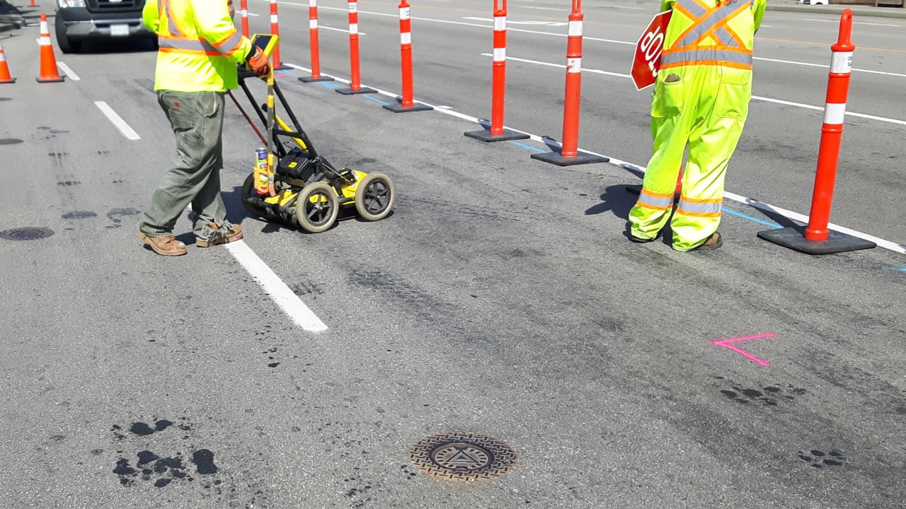
Utility locators are the quiet professionals who stand between a construction crew and a catastrophic underground utility strike. Their work — running locating equipment over a site, interpreting signals, marking accurate positions for every utility line — is what makes safe excavation possible. The path to becoming a competent utility locator has changed substantially in the past decade. Classroom theory still matters, but field practice with modern equipment, vendor-specific certifications, and exposure to advanced technology like Reality capture and 3D laser scanning now define the modern career.
Read on for a guide to the training programs, certification routes, equipment proficiencies, and continuing education that turn a candidate into a trusted professional. Util-Locate has trained and worked alongside utility locators across California and Arizona since 2001, and the patterns of what produces a reliable locator are consistent: layered instruction, real exposure to tools, and continuous learning as detection technology evolves.
Utility Locators Start With Foundational Classroom Training
The career path for utility locators typically begins with structured classroom instruction. These sessions establish the core knowledge base — what underground utilities exist, how each type behaves below the surface, the signal theory behind locating equipment, and the legal framework that governs every excavation project.
Most foundational programs cover:
- Categories of underground infrastructure: electric, gas, water, sewer, communication, and fiber optics
- How locating equipment generates and reads signals from buried pipes and cables
- The distinction between metallic and non-metallic pipes, and why detection methods differ
- Damage Prevention frameworks, the 811 system, Underground Awareness initiatives, and utility marking colors
- Quality Level A and Quality Level B mapping standards from ASCE 38
Industry experts and instructors with direct field experience lead the most effective sessions. Programs affiliated with Purdue University and similar academic institutions integrate research into the curriculum, exposing students to emerging tools like geographic information system platforms, GPS Mapping workflows, and the integration of CAD drawings into modern locating workflows.
Utility Locators Develop Skills Through Hands-On Field Instruction
Classroom theory only goes so far. Mastery requires extended practice with the actual equipment used in the field. Hands-on instruction is where students translate concepts into competence — running an electromagnetic locator, calibrating a transmitter, sweeping a site with Ground Penetrating Radar Systems, and interpreting the data in real time.
Effective hands-on instruction includes:
- Operating survey-grade GNSS receivers with NTRIP corrections for precise positioning
- Connecting transmitters through direct connection, inductive clamps, and surface induction modes
- Identifying utility targets in mixed-signal environments like the dense corridors of Los Angeles
- Practicing safe excavation procedures around marked utilities and sewer systems
- Capturing field data and exporting into Auto CAD or utility mapping platforms
Simulated exercises under the guidance of seasoned utility locators bridge the gap between learning and live work. Trainees who graduate from rigorous hands-on programs come out ready to contribute on day one rather than spending six months catching up to the rest of the crew.
Online Training, Quizzes, and Certification Assessments
Online training has reshaped how utility locators prepare for certification. The Underground Facility Locator certification and similar credentials are now accessible through structured online courses that combine video instruction, written modules, and assessment quizzes integrated into the curriculum. Vendor platforms offer their own online utility locator courses tied to specific equipment lines, and many state programs and the Common Ground Alliance recognize accredited online training as equivalent to in-person coursework.
The advantage for working professionals is significant. A utility locator can complete certification maintenance overnight or on weekends, keep current with new detection techniques, and document continuing education without leaving the job site. Online quizzes embedded in the modules serve as checkpoints that validate comprehension before a learner moves to the next unit. Final certification exams then verify proficiency across the full body of material.
Coursework often includes a unit on the factors that affect locating accuracy, which prepares utility locators to interpret signal noise, depth limitations, and conflicting readings on dense urban sites.
Utility Training Academies and Dedicated Learning Centers
Dedicated utility training academies provide a structured, immersive alternative to self-paced online learning. These programs combine a fixed-length curriculum with state-of-the-art labs, vendor-loaned equipment, and instructors drawn from working subject matter experts.
A well-designed academy program covers:
- Foundational utility locating theory and Damage Prevention frameworks
- Equipment operation across major detection categories — electromagnetic locator, GPR, sonde and duct rod, magnetic locator
- Subsurface Utility Engineering (SUE) and ASCE 38 quality levels
- Site characterization workflows, mapping, and 3D data collection
- Safety standards, quality audit procedures, and incident response protocols
Graduates leave with portable credentials and a clear competency baseline. Academies affiliated with established industry organizations also serve as networking hubs, connecting new utility locators with employers, certifying bodies, and regional chapters of professional associations.
Specialized Training: Gas Distribution, Cross-Disciplinary, and Technology Skills
Once core training is complete, specialized programs deepen specific competencies. Three branches of specialization stand out for serious career growth.
Gas Distribution and Leak Detection
Gas distribution work carries the highest stakes in utility locating. A strike on a gas line can cause explosion, asphyxiation, or large-scale evacuation. Specialized programs cover Acoustic Leak Detection, the use of Water Leak Detection Services equipment, and the specific behavior of buried gas pipes under varying soil conditions. Trainees learn to coordinate with gas utility contractors and recognize early signs of natural gas leaks during routine locating work.
Cross-Disciplinary Training
Utility locators benefit from coursework in adjacent disciplines. Civil engineering, geospatial technology, surveying, and environmental science all extend a locator’s capacity to contribute to complex infrastructure projects. Federal agencies like the Federal Highway Administration publish reference materials that connect utility locating to broader transportation work, including coordination with state DOTs and the National Highway System.
Technology-Specific Training: Reality Capture and 3D Mapping
Detection tools are no longer limited to the classic transmitter-receiver pair. Today’s utility locators increasingly work alongside Reality capture systems that produce Point cloud datasets from Laser scans and LiDAR technology. These datasets feed into BIM modeling workflows, Clash detection routines, and Revit models that engineers use to plan around buried utility infrastructure. Specialized courses cover how to integrate locator output with this geospatial pipeline — including processing into geographic information system platforms and Auto CAD deliverables.
The result is a deep technical toolkit and credible expertise that prepares utility locators for private utility locating sweeps and complex underground utility detection projects.
Equipment and Tools Every Utility Locator Should Know
Equipment proficiency is the part of the career that never stops developing. New models replace older ones, firmware updates change interface behavior, and capability expectations rise as projects grow more complex. The industry-standard equipment that working utility locators should be familiar with covers a few major categories:
- Electromagnetic locators and pipe and cable locators: the Schonstedt Maggie Magnetic Locator (a long-standing benchmark for ferrous-metal detection), Schonstedt u-Locate Set, Schonstedt REX pipe and cable locator, the SPX Radiodetection RD8200 Receiver and Radiodetection RD7200 receiver, the Vivax Metrotech vLoc3-Pro & Loc3-10Tx Utility Locator Set, the Vivax Metrotech vLoc3-RTK-Pro Utility Locator, 3M Utility Locators, the Subsite UtiliGuard Standard receiver, and the UtiliGuard 2 Utility Locating System and UtiliGuard 2 RTK Utility Locating System
- Ground Penetrating Radar: mid-frequency antennas paired with high-resolution receivers for both shallow concrete scanning and deeper soil work, including GeoRanger Ground Penetrating Radar units and similar platforms
- Utility Locating Beacons and sondes: for tracing non-metallic pipes, sewer systems, and other lines that conductive detection cannot reach
- Vacuum excavation rigs: including hydrovac truck operation for Quality Level A verification
- CCTV video cameras and Video Pipe Inspection systems: for inside-the-pipe locating and Concrete Scanning workflows
- Remote-controlled mini machines: for access into confined-space utility vaults that crews cannot safely enter
Each unit has unique Locator Function options, Transmitter Output settings, and a Coupler Cable system for direct-connect work. Vendor-specific training videos walk through the menus and setup, and most equipment manufacturers publish certification programs that confirm operator proficiency on their platform. Time spent learning each model deeply pays off — the same site can return very different readings depending on how the transmitter is set and whether the operator correctly interprets the receiver’s mode.
Mentorship, Field Internships, and Industry Collaboration
Formal training builds the foundation. Mentorship, field internships, and industry collaboration build the experience that turns a trained locator into a trusted one.
Mentorship programs pair new utility locators with seasoned professionals during the first one to two years on the job. Mentors model situational judgment that no curriculum can fully teach — how to handle a refusal signal, when to escalate to vacuum excavation, how to communicate ambiguous findings to project managers, and how to maintain a safety mindset under deadline pressure.
Field internships place trainees on live construction sites. The exposure to real soil conditions, utility congestion, weather variability, and time pressure forces adaptive thinking. Internships also teach the practical workflows of locating services — from pre-mark to walkout to documentation handoff. Many internships lead directly into full credentialing once the candidate clears a final assessment.
Industry collaboration keeps utility locators connected to the larger profession. Membership in the Common Ground Alliance, attendance at regional 811 summits, and participation in Underground Awareness programs expand a locator’s network and exposure to peer practices. State DOT initiatives often pilot new locating standards that filter into the broader industry within a few years.
Regional Training, Certification Maintenance, and Expert Input
The final layer keeps utility locators sharp through their entire career.
Regional training centers address the specific conditions of an operational area. A locator working in Los Angeles deals with very different soil, congestion patterns, and infrastructure age than one working in rural Arizona. Regional centers customize coursework around these conditions, including modules on coastal corrosion behavior, desert utility vault practices, and high-density urban locating procedures.
Certification maintenance courses are required by most certifying bodies to keep credentials active. These courses update locators on regulatory changes — new state guidelines, OSHA revisions, and California digging law compliance — and emerging detection methods. Completing maintenance on schedule is both a professional obligation and a competitive advantage.
Expert input rounds out the picture. Collaborative initiatives between certifying bodies and active utility locators incorporate field-tested practices, post-incident analyses, and lessons from major projects into the standing curriculum. The result is a training pipeline that improves continuously rather than going stale between revisions.
Train, Certify, and Trust Util-Locate’s Utility Locators on Your Next Project
Becoming a competent utility locator takes years of layered training and a lifetime of practice. Util-Locate has built its team around the same principles outlined here: classroom foundations, hands-on field practice, specialized certifications, mentorship, and continuous professional development. Our certified technicians work to ASCE-compliant standards and deliver Quality Level A and Quality Level B mapping data across Southern California, the San Francisco Bay Area, and Arizona.
If you’re planning a project that requires accurate locates — or if you’re looking for a trained partner to handle utility detection on your next site — Util-Locate is on call 24/7 for both routine and emergency work.
Call 1-888-885-6228 to speak with our team, or request a quote for your next excavation project. We deliver real-time on-site data, CAD and KML deliverables, and the certainty that comes from two decades of focused experience.
Frequently Asked Questions
What certifications do utility locators need?
Most working utility locators hold an Underground Facility Locator certification or a regional equivalent issued by a state utility commission or accredited training body. Many also carry vendor-specific certifications for Ground Penetrating Radar systems, magnetic locators like the Schonstedt Maggie, and survey-grade GNSS equipment. Certifications need periodic maintenance through update courses that cover regulatory changes, new detection technology, and refreshed safety standards. Locators working with gas distribution or hazardous materials often hold additional specialized credentials covering Acoustic Leak Detection and meter inspections.
How long does it take to become a certified utility locator?
A motivated trainee can complete foundational coursework and earn an initial Underground Facility Locator certification in three to six months. Field competence — the level needed to work independently on complex sites — typically takes one to two years of supervised practice. Reaching senior-level proficiency, where a utility locator can run private utility locating sweeps and manage Quality Level A mapping deliverables, generally requires three to five years of accumulated experience. Specialized credentials in gas distribution or Subsurface Utility Engineering add additional time depending on program length.
Which equipment should new utility locators learn first?
Start with the workhorse tools. An entry-level pairing like the Schonstedt u-Locate Set or a Radiodetection RD7200 receiver with a standard transmitter covers most basic conductive-line work. From there, move into more advanced platforms like the RD8200 Receiver, the Vivax Metrotech vLoc3-Pro, or the Subsite UtiliGuard 2 RTK Utility Locating System, which add depth estimation and multi-frequency selection. Ground Penetrating Radar Systems come next once the locator can handle non-conductive targets, and survey-grade GNSS units close the loop on mapping precision. Hands-on time with each model matters more than reading the manual.
How are utility locators using Reality capture and 3D mapping?
Reality capture combines Laser scans and LiDAR technology to produce Point cloud datasets of an entire site, above and below ground. Utility locators capture surface-marked positions and depth data, which then feeds into BIM modeling and Revit models that designers use for Clash detection between proposed infrastructure and existing buried utilities. The integration cuts errors during design and construction. Utility locators trained on this workflow are increasingly in demand for complex infrastructure projects where conventional 2D mapping is no longer sufficient.
How does industry collaboration improve utility locator outcomes?
Industry collaboration through bodies like the Common Ground Alliance, the 811 system, and the Federal Highway Administration creates shared standards that reduce utility strikes nationwide. Annual conferences and regional working groups give utility locators direct exposure to new detection methods, refined field procedures, and lessons from major incidents. The Common Ground Alliance’s annual DIRT Report on damage incidents is one of the most useful resources for understanding what causes utility damage and how training programs can adjust. Active participation also opens networking and continuing education opportunities that strengthen a locator’s career over time.