How Does Surface & Concrete Scanning Work?

concrete scanning

Ensuring that the concrete surrounding your construction site is safe is critical before you start your next big construction project. Since you might not be able to see underground utilities or confined areas that may be present as well, you may miss them. 

If there are things embedded in the concrete, this can be a potentially hazardous, complicated, and expensive project which may even result in accidents. When you can’t see through it, how can you tell if anything is inside? The solution to this problem lies in concrete scanning.

How Does Surface and Concrete Scanning Work

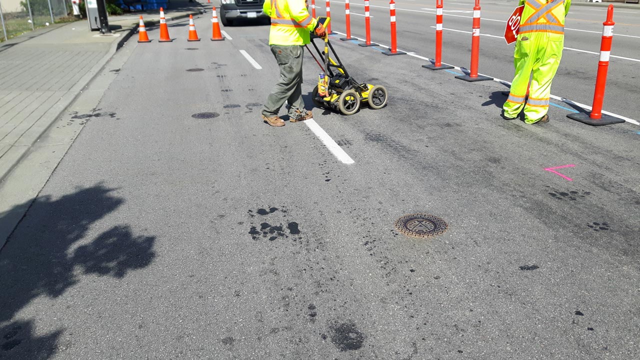
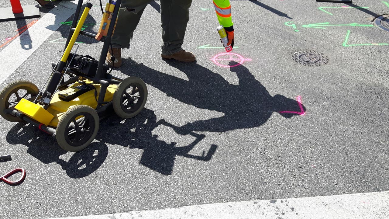
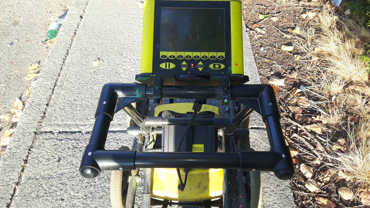
Before coring or drilling concrete slabs or columns, concrete surface scanning is used to inspect them. To provide quick and accurate concrete inspections, Ground Penetrating Radar (GPR) is used.

In both a safe and noninvasive way, GPR can detect embedded objects in the subsurface, whereas X-ray is less accurate in assessing concrete columns, slabs, and walls. It analyzes the subsurface using transmitted waves and their reflected signals. 

Scanners can detect hidden objects such as rebar, electrical conduit, post-tension cables, and voids in concrete. As well as concrete slab measurements and rebar spacing, it can be used for structural integrity reviews. Concrete imaging reading can be used if the material is located and its type is determined by an experienced technician.

When to Use Surface and Concrete Scanning

In order to scan concrete, a survey must be completed first. This is something land surveyors typically conduct when discovering new land, but it is just as useful on contemporary job sites.

A survey will reveal the location of utility lines as well as other features beneath the surface that may be hidden. Identifying all uncovered areas allows specialists in ground-penetrating radar to focus their use of concrete scanners where necessary.

How Does Concrete Scanning Help

Surface and concrete scanning contributes to the welfare of the workforce as well as the efficiency of concrete construction, reinforcing steel, installation of utilities, the control of traffic, as well as the repair of underground utilities. Concrete structures are protected from damage when you identify embedded materials with markings in order to reduce the chance of invasive work in these areas.

In the event of a structural failure due to rebar and post-tension cable damage occurs, you risk endangering the lives of employees on site. Electrocution or death can occur if electrical conduits and services are damaged within concrete.

With scanning concrete integrated into your process, you can work more quickly and efficiently while guiding the project’s development. Before any of your workers begin work on their latest job site, you’ll stay under budget and meet the timetables outlined.

Hire Professionals in Your Next Concrete Scanning Project

It is definitely necessary to plan for GPR on the site if an existing concrete structure or utility features are involved, such as concrete floors. In areas with older construction, it’s particularly common to find unmarked utilities when planning the installation, inspection, or repair of subsurface utilities. With GPR onsite, you can avoid these unpleasant surprises.

The technicians at Util-Locate are well-trained, highly skilled, and experienced in handling all home or business service requests promptly and efficiently. We can assist you with concrete scanning services by giving us a call at 1 (888) 88 56228.

3 Different Ways for Concrete Imaging and Scanning

3 Different Ways for Concrete Imaging and Scanning

If you’re wondering about the safety of drilling into concrete slabs and other structures, what you need to get peace of mind is concrete scanning and imaging. This is a series of non-destructive tests (NDT) for detecting and measuring flaws or imperfections beneath concrete surfaces.

In the past few decades, numerous imaging and scanning technologies have emerged. Before hiring professionals for surface and concrete scanning solutions, you should first gain a deep understanding of those technologies, and the reason why concrete imaging and scanning are important.

Why is Concrete Scanning Important?

There is always the chance of damaging vital infrastructure while cutting, coring, drilling, or sawing existing concrete slabs. This includes embedded materials like communications and electrical conduits, post tension cables, reinforcing steel, void defections, and refrigerant and plumbing piping.

Skipping out on the scanning process could mean project delays, additional costs, and injuries on the job site. Project managers certainly don’t need any added stress, so scanning and imaging services are always a must before starting a construction project.

3 Methods of Concrete Scanning and Imaging

Now that you know how important scanning and utility locating services are, it’s time to dive in on the various methods and scanning equipment.

1. Ground Penetrating Radar

To scan concrete without causing any damage, ground penetrating radar (GPR) is commonly utilized.  To detect subsurface objects, the GPR sends out electromagnetic pulses or radar pulses with a very particular core frequency.

The antenna then picks up the waves that have been reflected from underground layers, revealing the buried objects.

Choose Ground Penetrating Radar if you need to:

  • Find a safe place to drill, cut, or demolish
  • Locate objects such as post tension cables, rebar, reinforcing steel, and metallic or non-metallic conduits
  • Measure concrete cover and thickness
  • Determine the concrete’s internal condition
  • Uncover defects or voids in concrete

2. Ultrasonic Tomography

This acoustic method efficiently identifies defects in concrete no matter how complex the concrete slab is. This also helps when assessing the thickness and overall strength of concrete structures. It does it through transmitters that send pulses into test objects.

Any reflected signals indicate the presence of defects or interfaces. Using a receiving transducer, technicians can keep a close eye on emitted impulses and reflected waves.

Choose Ultrasonic Tomography if you need to:

  • Precisely measure the thickness of concrete up to 3 feet
  • Detect any cracks or delamination between the Portland Cement Concrete (PCC) layers
  • Locate steel reinforcement
  • Determine deterioration, dowel position, and spalling at PCC joints
  • Learn about material properties like the diagnostics of PCC strengths and asphalt compaction levels

3. Radiography Via X-Ray

X-ray scanning may appear to be outdated technology. Nonetheless, it is dependable in terms of providing a clear picture of what lies beneath. Because X-rays provide less room for interpretation of results—including the status of rebars, corrosion zones, and other faults—they are sometimes even considered more precise compared to GPR.

Unfortunately, this can also emit harmful radiation, and the process is slower overall, with images having to be produced off-site.

Choose Radiography Via X-Ray if you need to:

  • Identify where rebars are situated.
  • Evaluate bar diameter and depth below the surface
  • Search for cracks, foreign materials, and voids
  • Locate variations in density or the presence or absence of grouting in post-tension construction
  • Check welds on pipelines
  • Inspect steelwork production
  • Determine the level of internal and external corrosion

Find Reliable Surface and Concrete Scanning Solutions Today!

Now that you fully understand the various techniques of concrete imaging and scanning, it’s time to hire a surface and concrete scanning solutions professional.

Ensure safety and be proactive with damage prevention when you work with us, contact us at 888-885-6228 at Util-Locate today!

What is Concrete Scanning and What Can It Find?

What is Concrete Scanning and What Can It Find?

Before a renovation or construction project begins, concrete scanning is essential. This is the process of evaluating concrete slabs or columns before core drilling. Typically, technology like Ground Penetrating Radar (GPR) is used to spot buried and embedded objects. However, this method is ideal because it’s completely safe and nondestructive.

If you think that you need surface and concrete scanning solutions, it’s best to learn about the ins and outs of the process first. Let’s start with what exactly happens during a typical inspection of a concrete slab.

What Happens During Concrete Scanning?

During a concrete scan, a professional will deliver high-frequency electromagnetic waves using GPR technology through your concrete floor or wall.

Another specialist will then come in to interpret the data provided by the scanner. From there, they’ll be able to show you what’s hidden underneath your concrete and where it is exactly.

Types of Concrete Structures that Need to be Scanned

Any concrete surface can and should be scanned before any cutting or drilling is done. Some samples of structures that need to be scanned are provided below.

  • Slab on grade
  • Roadways
  • Bridges
  • Beams
  • Decks
  • Pylons
  • Walls
  • Balconies
  • Encasements
  • Tunnels
  • Sidewalks
  • Columns
  • Floors
  • Ceilings

Common Objects Found During Concrete Scanning

A proper concrete scan can uncover a large variety of objects in your chosen area. Below are just a few examples:

  • Metal rebars and other reinforcing steel members
  • Post-tension cables
  • Electrical conduits
  • Piping
  • Plastic tubing
  • Water lines

The Importance of Concrete Inspection

Before you do any work on your concrete like drilling, cutting, or repairing, you must first determine where utilities and reinforcements are located. This will save you time since you won’t have to spend hours looking for a secure area where you can start working on.

Investing in concrete scanning can also guarantee that you’ll be able to cut and drill safely without harming your tools or the materials that are hidden underneath the concrete.

Additionally, the process can help ensure and maintain the structural integrity of a structure’s foundation.

Check out even more benefits of concrete scanning services:

  • Reduces the possibility of damage to utilities, rebar, post-tension cables, pipes, and conduits
  • Lowers the risk of personal injury
  • Prevents costly mid-project repairs
  • Simplifies drilling, cutting, and coring

How Much Does Concrete Scanning Cost?

Important factors to consider when determining the price of a concrete scan are the location, area size, and the complexity of embedded materials. That said, the cost varies widely from case to case.

Don’t let this discourage you though. Just think of the construction delays, additional costs, and other possible headaches that can be put to rest with a carefully planned and scheduled concrete scan.

Experience Reliable Surface and Concrete Scanning Solutions Today!

Our skilled professionals are prepared to provide you with reliable surface and concrete scanning solutions services. With over 13 years of industry experience coupled with cutting-edge technology, we can give you the results that you want.

If you want to learn more about our concrete scanning services, you may fill out our online form or contact us at 888-885-6228 at Util-Locate right away!

3 Reasons to Call In Utility Potholing Services

3 Reasons to Call In Utility Potholing Services

Before an excavation or construction project begins, it is necessary to perform potholing for utilities. Professional utility potholing is a non-destructive method of determining the exact placement of all underground utility lines. 

This utility location method is usually carried out by excavating carefully-planned areas around and above utility wires using a portable vacuum excavator that removes dirt and debris. During potholing, utility crews may come across gas, water, electrical, and sewage lines. 

Small test holes may also be created in the earth for finding underground utilities like sewer pipes and utility lines. Potholing techniques eliminate risk by informing builders of the precise location of utilities before breaking ground.

Why Do You Need Professional Utility Potholing Services?

To give you a better understanding of potholing services and why you need them, we’ve broken down three benefits below.

1. It Helps Prevent Damages in Utility Lines

While digging, there’s a huge possibility that you may damage underground utilities. That will require a lot of labor and money to fix, not to mention the service outages that will inevitably occur in the digging process. You can be proactive and easily prevent service interruptions through utility potholing and utility maps.

2. It is Required in Many States

Many states prohibit the operation of heavy machinery within a certain distance of buried utility lines. Doing so exposes employees to a multitude of dangers. That is why most businesses must hire utility potholing services before the excavation starts.

3. It Ensures the Safety of Your Business Location

Understanding and maintaining your work site begins with potholing. Whether you’re laying new foundations or rerouting existing utilities and underground lines, you must know how things stand with your underground infrastructure.

Most Popular Potholing Technique

There are two popular potholing methods commonly used in the construction industry.

Hydrovac Excavation

Hydro excavation is the preferred method of many due to its accuracy compared to other methods. This potholing process moves the soil carefully using high-pressure water and a hose. The excavated material is then dumped into a debris tank.

Additionally, hydro vac excavation is advantageous because it uses water, which serves as a non-conductor. This becomes all the more critical when considering the safety of crew members while working with live electrical wires.

Vacuum Excavation

Another method of potholing is vacuum excavation, also known as air excavation. This technique uses a portable and pressurized device that utilizes air to extract soil via high-speed suction. Once the dirt is removed, it is either dried out or stored in a holding tank until it may be reused later.

An excavator’s fuel tank capacity can be anywhere from 100 to 1,200 gallons. Some potholing professionals believe this is the most secure means of excavating near utilities since they use low-pressure air.

Need Reliable Potholing Services For Your Construction Projects?

In every construction project, safety comes first. That’s why before you even think about digging or potholing utilities, you should reach out to Util-Locate first!

Through game-changing technology and years of proven expertise, you won’t be disappointed by our utility potholing services.

Contact us at (714) 492-1380 or via email at info@util-locate.com to find out how we can assist you today!

Ground Penetrating Radar 101: The Basics

Ground Penetrating Radar 101: The Basics

Ground-penetrating radar (GPR) equipment, also known as ground probing radar, is used in geological surveying like utility mapping.

What is a GPR?

The GPR technology is a very important set of equipment for those who are working in non-invasive surveying, especially during utility mapping. A GPR system allows underground utilities to be found as well as other subsurface objects like conduits, rebar, voids, and other characteristics of the ground.

How Does a Ground Penetrating Radar Technology Work?

Ground-penetrating radar technology uses an energy pulse to generate images underneath the job site. A computer receives the output and it undergoes data processing to perform its subsurface investigation. It takes the strength and time delay of the outgoing and returning signals and uses them to convert the data collected onto digital media.

It works because different material properties affect the electromagnetic pulse. Factors can affect these signals, which include:

  • Soil conditions
  • Buried objects
  • Freshwater
  • Concrete, dry sand
  • Wet sand
  • Sandy soils
  • Depth
  • Other structural elements
  • Subsurface features

This powerful tool is not limited by surface either. A GPR system can work on a variety of different surfaces like soil, ice, rock, fresh water, pavements, and concrete structures to name just a few.

It is versatile in its uses such as locating rebar, subsurface structures, or buried objects—even going as far as identifying the make and material of it.

Benefits of Utilizing Ground Penetrating Radar Equipment

GPR has a variety of uses and benefits. Its ability to identify metallic and non-metallic utilities and services, as well as work in unfavorable and favorable conditions makes it an indispensable tool in the field.

The collected data not only gives you the depth of the main components of a material, but also allows workers to identify polyethylene water and gas pipes, fiber-optic cables, and other elements that would otherwise be undetectable.

Data is gathered when combined with other collecting devices and systems like electromagnetic energy detection, accurate specific depths, the minor differences between two materials, small objects, large objects, subsurface mechanical properties, and a range of other information.

These systems can function in remote sensing work with accurate and reliable results. The resulting GPR data can ensure that no sensitive sites are disturbed by digging. The use of radar provides cost and time-saving benefits over older techniques such as x-rays.

These devices can use the data from these reflected signals to give early warning signs before any damage is made or before anyone is exposed to any dangers during construction. In the event of an already existing problem, this radar signal device can help diagnose the problem quicker and more accurately.

These machines have a place outside of construction and infrastructure as well. They can be used in geological studies and geophysics. They are used in environmental surveys and the study and assessments of earthquakes. They’re even used in the study of trenchless technology and directional drilling.

Find a Reliable Ground Probing Radar for Your Needs

If you’re looking for a GPR service you can trust, our team of experts is ready to take on the job and provide you with high-quality work. We use the latest equipment and cutting-edge technologies.

We produce cost-effective, fast, efficient, and accurate GPR survey solutions that stem from over 13 years of experience.

To learn more about our GPR services, contact us at 888-885-6228 at Util-Locate today!

3 Things to Know About Utility Mapping

3 Things to Know About Utility Mapping

There is always a risk of hitting utility pipelines or wires when digging into the ground during construction. This can be incredibly dangerous and costly should an accident like this happen. That’s why it’s important to hire a professional utility mapping service to get the job done.

Moreover, having an accurate plan when mapping out where to dig is essential. This is especially true in areas where utilities like gas lines and electrical power lines can be found.

This is where utility mapping and utility mapping services come in.

Understanding Utility Mapping

To put it simply, a utility map shows you data regarding the locations and identifications of pipes and cables beneath the ground. This involves sewers, electric utilities, telephone cables, gas lines, and water mains.

This process together with topographical surveys will create a detailed map of the configuration of anything below an area with great accuracy.

Keeping You Safe

Experienced utility mapping services can be crucial to any project, infrastructure, or construction site of any kind. Safety should always be the number one priority—and the greatest contributor to it is knowledge and information.

You’ll find reliable utility mapping services in Orange County, Los Angeles, Riverside, and many other places, making sure that they provide and ensure a safe environment during construction.

What’s next after the completion of the projects is one of the ultimate goals of utility mapping. Always be sure to find, contact, discuss, or even meet with professional services and their team to keep people involved in any project out of harm.

Public health and safety should also be a top priority in any project. That’s why it’s important to not be cutting corners—to choose reliable utility mapping services that can help project managers understand all the information they need to know before digging any ground.

Hitting a gas pipeline is no laughing matter. Even if there are instances where workers and civilians manage to be unharmed, accurate knowledge and data could easily ensure their safety.

Avoiding What Could Go Wrong

Everyone at a worksite has the right to health and safety, and there are many things that could go wrong when the location of utilities underneath an infrastructure is overlooked.

There is a threat of electrocution, fire, or other dangerous hazards, and failing to have quality data about the project area can multiply these dangers exponentially.

Utility work-related accidents that happened in the past and continue to happen today—like flash burns, accidentally striking an electric cable, and expensive damages to private and public utilities. These are unnecessary and readily avoidable risks that could cost money and people.

Utility Mapping Service You Can Trust

For any type of infrastructure, be sure to do research beforehand and search for a reliable service that can provide you with life and cost-saving data. This data could make the entire process easier and safer for everyone involved.

For utility mapping services our team of skilled experts in the industry can ensure you a reliable, trustworthy, and professional job.

To learn more about our services, email us at info@util-locate.com on contact us at 888-885-6228 at Util-Locate today!