Key Takeaways
- 811 markings comply with the law but don’t prevent strikes: Markings show approximate horizontal location only, no depth, no private utilities, 20+ foot deviations common. 94% of strikes result from incomplete data, not excavator error.
- SUE Quality Levels match accuracy to decisions: QL-D records ($0-$500) for feasibility, QL-B mapping ($1,000-$8,000) for design at ±1 ft, QL-A verification ($700-$1,100/hole) for ±0.04 ft precision. Wrong choice means 10-30x cost increases.
- ROI is immediate: $15,000 investment prevents $56,000 in strikes, $39,500 net savings with $4.62-$22.21 return per dollar. Pure Water saved $76M; Orion paid $1.26M for bad data.
- San Diego’s subsurface exceeds map complexity: UUD conversions, ownership changes, and abandoned infrastructure make 811-only insufficient. Accurate data becomes a permanent asset for future development.
- Systematic verification works: SDG&E cut dig-ins 54.9% despite 50% more activity. The same approach prevents conflicts, eliminates claims, and protects schedules.
The difference between a smooth commercial build and a seven-figure dispute often comes down to one choice: how well you verify what’s underground before you dig. In San Diego, some teams prove what’s possible, SDG&E cut gas dig-ins by roughly 55%, and Pure Water avoided $76M by resolving conflicts in design. Others pay for “paint-only certainty,” like the Mission Beach Orion project: a $1.26M settlement, 159 working days lost, and major productivity hits.
That gap isn’t luck. It’s data quality. 811 markings meet the legal requirement, but they provide approximate horizontal location only, no depth, no private utilities, and deviations that can be 20+ feet. For commercial work involving foundations, deep excavation, shoring, or tie-ins, that’s not enough.
This guide explains when 811 markings are sufficient, when Subsurface Utility Engineering (SUE) mapping is the smarter requirement, and how matching SUE quality levels to project decisions prevents avoidable strikes, claims, and schedule blowups.
What Problem Are We Solving When We Talk About “Surface Markings vs. Utility Mapping” On San Diego Commercial Sites?
Utility strikes cost the U.S. construction industry $30-62 billion annually, with the average incident carrying a $56,000 price tag. The root cause isn’t careless excavation, 94% of strikes result from incomplete or inaccurate subsurface data. San Diego commercial projects face this risk daily, which is why understanding utility locating risk in San Diego is critical for project success.
The Orion Construction case in Mission Beach illustrates the scale of the problem. The City provided maps showing 160 underground utilities. The contractor encountered 324, more than double the expected number. The result: a $1.26 million settlement and 159 working days of delay. This wasn’t an excavation error. It was a data failure.
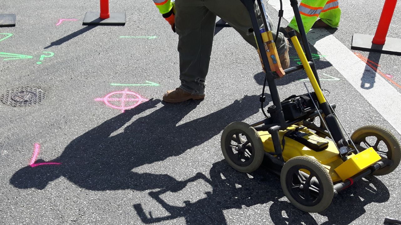
Standard 811 surface markings provide only an approximate horizontal location. They don’t reveal depth, material, condition, or the private utilities that exist on nearly every commercial site. For projects involving trenching, pile driving, or underground tie-ins, approximation isn’t good enough.
The gap between what 811 provides and what construction needs creates predictable, expensive failures. Professional utility mapping services close that gap with engineered, surveyed data.
What Do Surface Utility Markings Actually Mean, And Not Mean?
California Government Code 4216 requires excavators to contact DigAlert/811 at least two working days before digging. Failure carries penalties up to $10,000 per violation. As of January 1, 2025, strengthened “positive response” requirements mean you cannot proceed until operators confirm their facility status. But compliance with 811 law doesn’t eliminate risk, it establishes a legal baseline, not engineering certainty. Surface markings show approximate horizontal location only.
They provide no depth data, no verification of accuracy, and no coverage of private utilities. The limitations of paint-only locates become especially problematic on complex commercial sites where precision matters.
| What markings provide | What they DON’T provide | Risk created | What you need instead |
| Approximate horizontal location | Depth information | Deep excavation strikes | QL-A potholing for depth |
| Utility-owner facilities only | Private utilities (fire, irrigation, site lighting) | Striking unmarked site utilities | Private as-built research + QL-B |
| Location within ±24″ tolerance zone | Precise position for design | Conflicts discovered during construction | QL-B for design accuracy (±1 ft) |
| Snapshot valid ~28 days | Updates as site changes | Working with outdated marks | Re-ticket each phase |
Key stat: Over 20% of utilities marked via 811 systems deviate by more than 20 feet from their actual location.
What Is Utility Mapping (SUE), And What Do The Quality Levels Mean?
The American Society of Civil Engineers standard ASCE 38-02 defines four Quality Levels (QL-D through QL-A) for Subsurface Utility Engineering. Each level provides different accuracy and serves different project needs. QL-D relies on existing records, the same data that led to Orion Construction encountering double the expected utilities. QL-C adds surveys of visible features like manholes. QL-B uses geophysical methods (Ground Penetrating Radar, electromagnetic location) to map utilities horizontally and vertically with ±1 foot accuracy. QL-A physically exposes utilities through vacuum excavation, providing ±0.04 feet (roughly half-inch) precision.
The quality level determines what decisions you can confidently make. QL-D supports feasibility studies. QL-B enables design and conflict identification. QL-A verifies critical crossings and provides tie-in data. Choosing the wrong level means either spending money you don’t need to spend, or, more commonly, discovering expensive conflicts during construction when fixes cost 10-30 times more.
This is why documentation matters for remodels and renovations, having surveyed utility data eliminates guesswork when modifying existing buildings.
| Quality Level | What it provides | Accuracy | When to use | Cost range |
| QL-D | Desktop records review | Unknown (often ±20+ ft) | Concept/feasibility only | $0-$500 |
| QL-C | Records + surveyed surface features | Varies | Site planning | Minimal add to QL-D |
| QL-B | Geophysics (GPR, EM location) | ±1 foot horizontal/vertical | Design phase; conflict ID | $1,000-$8,000 |
| QL-A | Physical exposure (vacuum excavation) | ±0.04 feet (½ inch) | Critical crossings; tie-ins; deep excavation | $700-$1,100 per hole |
Why Are Surface Markings Alone Not Enough For San Diego Commercial Projects?
A utility mark can be “correct” under 811 standards and still destroy your schedule. The tolerance zone (typically 24 inches on either side of the mark) is wide enough to hide major conflicts. The marks don’t account for depth; a line marked at grade could be 2 feet deep or 12 feet deep. And private utilities, irrigation, site lighting, fire systems, telecommunications equipment, won’t be marked at all because they’re not in public operator databases.
San Diego adds specific complications. Municipal Code §51.312 mandates utility undergrounding in Underground Utility Districts (UUDs), creating conversion zones where overhead and underground systems overlap. Decades of property ownership changes mean incomplete record handoffs. The result is a subsurface environment more complex than maps suggest.
This complexity underscores the long-term value for property owners who invest in comprehensive utility mapping; accurate subsurface data becomes a valuable asset for future improvements, tenant modifications, and property transactions.
Why San Diego commercial sites have high unknown-utility rates:
- Underground Utility District (UUD) conversions add complexity with overhead-to-underground transitions
- Multiple decades of property ownership changes = incomplete record handoffs
- Private utilities (parking lot lighting, irrigation, fire systems) not in public records
- Abandoned legacy lines left in place during upgrades
- Repeated trenching over decades creates unmarked crossings
What Are The Real Consequences Of Relying On Markings-Only?
The difference between adequate utility data and inadequate data is measured in millions of dollars and months of schedule. Two San Diego projects illustrate the extremes. One relied on city-provided maps and paid a seven-figure settlement. The other invested in design-phase conflict avoidance and saved $76 million. Understanding how utility mapping prevents construction delays is essential for every project stakeholder.
Orion Construction (Mission Beach) – The Cost Of Inaccuracy
City maps showed 160 utilities. The contractor encountered 324, more than double the expected number. Productivity collapsed from 75 feet of pipe installed per day to 20-50 feet per day when crews hit unmapped conflicts. The planned 320 working days stretched to 479 days, a 159-day overrun. The financial result: a $1.26 million settlement paid by the City of San Diego to cover delay costs and extra work. This wasn’t a construction failure. It was a data failure with a seven-figure price tag.
Pure Water San Diego – The Value Of Proactive Mapping
The multi-billion-dollar Pure Water Program took the opposite approach. Construction management staff and designers partnered to realign pipelines during the design phase, deliberately routing them away from existing SDG&E infrastructure. This proactive conflict avoidance reduced estimated utility relocation costs from $120 million to $44 million, a $76 million cost avoidance.
The strategy worked because the team had accurate subsurface data before committing to a design. They engineered solutions to avoid conflicts rather than discovering them with a backhoe.
| Cost category | Example from San Diego | Typical range | How QL-B/QL-A prevents it |
| Claims/settlements | Orion: $1.26M | $50K-$2M+ | Accurate data eliminates differing conditions claims |
| Project delays | Orion: 159 days | Weeks to months | Conflict resolution in design phase |
| Emergency repairs | Utility strike restoration | $4K-$15K per incident | QL-A verification prevents strikes |
| Redesign mid-construction | Pure Water alternative: $76M avoided | $15K-$50K+ | QL-B identifies conflicts before bidding |
| Productivity loss | Orion: 67% drop in install rate | $2K+ per hour of standby | Known conflicts = maintained productivity |
How Do Markings And Mapping Compare Across Project Phases?
The value of surface markings versus utility mapping changes dramatically depending on the project phase. During design, 811 markings provide zero value; they’re not surveyable data and can’t inform engineering decisions. During excavation, they’re legally required but insufficient without verification. The optimal approach layers methods based on the decision being made.
SDG&E’s gas utility program demonstrates what systematic verification achieves. From 2019 to 2023, the dig-in rate dropped 54.9%, from 2.46 to 1.11 incidents per 1,000 tickets, despite a 50% increase in excavation activity. This wasn’t luck. It was the result of proactive damage prevention programs that went beyond basic 811 compliance.
| Project phase | Surface markings value | Mapping (SUE) value | Recommended approach |
| Design (SD/DD) | None – too inaccurate | QL-B identifies conflicts for design solutions | QL-B comprehensive |
| Permitting/bidding | None – not surveyable data | QL-B data supports permit drawings & accurate bids | QL-B deliverables in bid package |
| Pre-construction | Reference only | QL-A at known conflicts before mobilization | Update QL-B + targeted QL-A |
| Foundation/shoring | Required by law (811) | QL-A mandatory at each conflict | Both: 811 + QL-A verification |
| Utility tie-ins | Required by law (811) | QL-A mandatory at connection points | Both: 811 + QL-A before cutting |
Success metric: SDG&E achieved 54.9% reduction in gas dig-in rate (2.46 to 1.11 per 1,000 tickets) from 2019-2023, despite 50% increase in excavation activity, proof that proactive programs work.
What Does “More Than Markings” Look Like In Practice?
“More than markings” is a layered approach: start with broad, low-cost research and add precision only where the consequences justify it. QL-D establishes the baseline, QL-B maps utilities accurately enough for design, and QL-A confirms critical conflicts where there’s no room for error.
The deliverable should be surveyed, CAD/BIM-ready utility data, not just field paint, with metadata (quality level, method, date, and required verification points) so designers and field crews know what’s confirmed and what still needs potholing before excavation.
What’s The ROI, And When Does It Pay For Itself?
Utility mapping usually pays for itself by preventing the first conflict. On a typical $10M San Diego commercial project, a full SUE approach (QL-B plus targeted QL-A) costs about $15,000 versus an average $56,000 utility strike, roughly $39,500 in net savings if it prevents one incident.
Industry ROI ranges of $4.62–$22.21 returned per $1 invested align with local results like Pure Water San Diego’s $76M in avoided costs by identifying and resolving conflicts during design. The tradeoff is simple: pay a predictable upfront cost or absorb unpredictable mid-construction costs and delays.
When Is Markings-Only Acceptable vs. When Do You Need Mapping?
Markings-only can be sufficient for shallow, low-consequence work where hand-digging is practical and an unexpected utility won’t materially impact safety, schedule, or cost. The moment excavation becomes deeper, structural, or requires tie-ins, surface markings stop being decision-grade information.
In San Diego’s dense commercial corridors, especially downtown, redevelopments, and Underground Utility District areas, utility congestion, legacy lines, and incomplete records make mapping a risk-control step, not an optional upgrade, particularly for schedule-sensitive sites like hospitals, data centers, and occupied buildings.
How Do You Select A Mapping Partner And Scope Deliverables?
Not all utility locating services are equal. Traditional “locating” marks the ground with paint and provides no engineered deliverable. Subsurface Utility Engineering (SUE) produces surveyed, CAD-integrated data with quality levels, metadata, and limitations clearly documented. The procurement language matters, vague specifications produce vague results. Define exactly what you’re buying: ASCE 38-02 compliance, specific file formats, coordinate systems tied to project control, and metadata that includes verification method, date, and confidence rating for each feature.
Red flags indicate you’re buying basic locating dressed up as engineering. If the proposal doesn’t reference ASCE 38-02 quality levels, doesn’t include a CAD deliverable, or makes overconfident accuracy claims without physical verification (QL-A), you’re not getting utility mapping, you’re getting expensive paint on the ground. Why documentation matters for remodels becomes clear when you compare a paint-only locate that washes away in the first rain to a permanent CAD file that serves the property for decades.
Procurement language to include:
- Explicit ASCE 38-02 compliance for quality levels
- Specific deliverables: CAD format, layer structure, coordinate system
- Metadata requirements: method, date, confidence rating, depth accuracy per feature
- Limitations disclosure required (what was NOT surveyed and why)
- QA/QC process defined (peer review, spot verification)
Red flags you’re buying locating (not mapping):
- No quality levels or ASCE standards mentioned
- No CAD/GIS deliverable, just field paint/flags
- No metadata or limitations section
- Overconfident depth claims without QL-A verification (“accurate to 2 inches from GPR”)
- No survey control or tie-in to project benchmarks
What Should San Diego Commercial Teams Do Next?
The path forward is straightforward: standardize utility mapping in project specifications, budget appropriately, and integrate the data into field operations. Add QL-B as the minimum requirement for design phases and QL-A verification at known conflicts before excavation. For most San Diego commercial sites, comprehensive SUE costs $8,000-$15,000, a fraction of the cost of a single utility strike or one week of schedule delay.
Verify Underground Utility District status early. San Diego Municipal Code §51.312 imposes mandatory undergrounding requirements that affect project scope and cost. Establish triggers for re-verification: when phasing changes, when schedule delays exceed 90 days, or when site conditions change. Most importantly, brief field crews daily on SUE findings. Accurate data only prevents strikes if the crew operating the excavator knows where the conflicts are and where hand-digging is mandatory. Contact a qualified utility locating provider to start the process.
Immediate action steps:
- Add SUE to standard specs: Require QL-B minimum for design; QL-A at critical conflicts
- Budget appropriately: $8K-$15K for comprehensive SUE on typical commercial site
- Verify UUD status early: Check San Diego Municipal Code §51.312 for undergrounding requirements
- Standardize deliverables: Define CAD format, metadata, quality level requirements in RFP
- Establish refresh triggers: Re-verify when phasing changes or after 90+ day delays
- Brief the field: Integrate SUE findings into daily crew briefings; mark hand-dig zones
Key takeaway: San Diego has proven proactive damage prevention works (SDG&E’s 55% strike reduction). The question is not whether you can afford to invest in mapping, it’s whether you can afford another Orion Construction scenario ($1.26M settlement, 159-day delay) when a $15K SUE investment could have prevented it.
The Cost Of Knowing vs. The Cost Of Guessing
The evidence is unambiguous: utility mapping isn’t an expense, it’s insurance with a guaranteed positive return. San Diego has proven the model works. SDG&E’s 55% strike reduction and Pure Water’s $76 million in avoided costs demonstrate what systematic subsurface verification achieves. The Orion Construction case demonstrates the alternative: $1.26 million settlements and 159-day delays when you guess instead of know.
Every San Diego commercial developer now faces a binary choice. Invest $8,000-$15,000 in QL-B and QL-A verification during design and pre-construction, or accept the statistical probability of a $56,000 utility strike with cascading schedule and cost impacts. The limitations of paint-only locates are well-documented. The long-term value for property owners who invest in comprehensive utility mapping extends beyond the immediate project; accurate CAD deliverables become permanent assets for future tenant improvements, expansions, and property transactions.
The question isn’t whether you can afford utility mapping. The question is whether you can afford to proceed without it when the data proves that inadequate subsurface information is the root cause of 94% of utility strikes. Start with three actions: add QL-B to design-phase specifications, budget appropriately for comprehensive SUE, and verify UUD status before finalizing project scope. The cost of accurate data is a fraction of the cost of discovering you didn’t have it.
Request A Utility Locating Quote
Ready to protect your next San Diego commercial project from utility conflicts? Contact Util-Locate for ASCE 38-02 compliant subsurface utility engineering that delivers the data your project needs before the first shovel hits the ground.