How the Murrieta Explosion Could Have Been Avoided

murrieta explosion


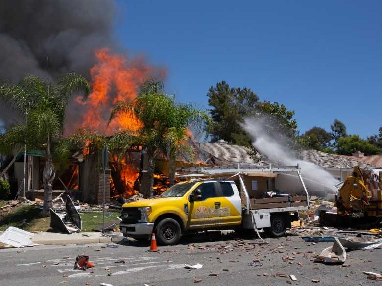
Southern California was recently devastated when a ruptured gas line led to an explosion. The explosion killed a Southern California Gas Company worker, and fifteen people were injured.

Murrieta Explosion The reason behind the Murietta explosion was a contractor who was working without having the area inspected first. The contractor not only caused irreversible damage but violated state law by not utilizing a  private utility locating service. Tragedies like this can be avoided when proper utility potholing and inspections are used.
 

What is Utility Potholing?

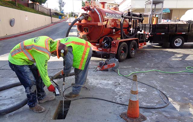
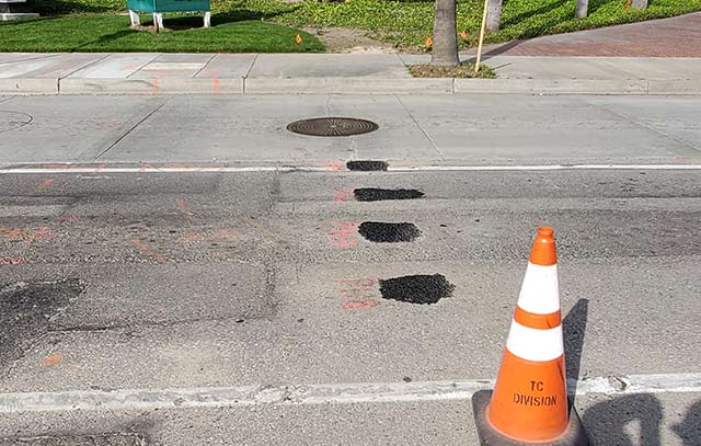
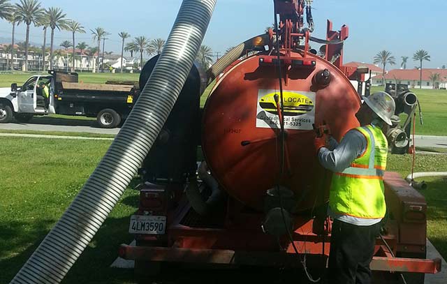
Potholing is a construction method that confirms underground utilities and obstructions. Utility locating is the first part of the investigation process. A small, exploratory hole is dug along the planned route of new construction. Air and hydro vacuums are used to remove soil via high-velocity suction.

Some contractors like to use digital locators to find pipes and other utility lines. There are many occasions, however, where it is essential to actually see where the wire or pipe is located.

Why Pothole?

Murrieta Explosion

Digging without first locating underground utilities creates a risk to gas, electric, communications, water, and sewer lines. Accidents with these lines can result in service disruption, costly repairs, serious injuries, or death. While it may mean delaying a project, knowing where lines are before you dig ultimately makes sure projects are entirely safe.


Why vacuum excavation?

In the past, potholes were dug with large machines, like backhoes. Unfortunately, even a skilled backhoe user runs the risk of damaging the very utility they wanted to protect. Some companies resort to digging by hand. While this method required less machinery and skill, it is somewhat labor-intensive. A shovel is unlikely to cause damage to a water pipe, but could completely sever fiber optics or other communication lines.

The current preferred method of potholing is vacuum excavation. Vacuum excavation happens after utility locating and verifies the utilities by exposing them for visual identification. This method allows for small holes to be created with a much lower risk of additional damage. Vacuums also can create holes of different sizes and depths without extra manual labor. Read more about how to pothole for utilities.

utility potholing

Plan before you dig!

Whether you are doing the work yourself or hiring a contractor to take over, you must plan appropriately. Even smaller projects, such as planting trees or shrubs, require knowing what’s beneath the ground. Many utilities are only buried a few inches below ground, which makes them easier to hit when performing simple gardening projects.

Make sure to call several days before you plan on putting a shovel to the ground. Be careful as some programs only mark the area where utility lines are placed. You may also have to wait for multiple companies to take care of marking the area. Also, be aware that utility companies may not go onto private property. For a better response and completion time, consider going with a private utility locator company.

While some accidents are avoidable, many accidents don’t need to happen. Murrieta Explosion The explosion in Murrieta destroyed more than a house; it took a person’s life. Contractors might think they know better, that they are skilled enough to work around utilities, or they want to save time on a project. However, taking the extra time to identify underground obstructions is the best way to ensure your project is completed without tragedy.

How to Prevent Damage to Underground Utilities

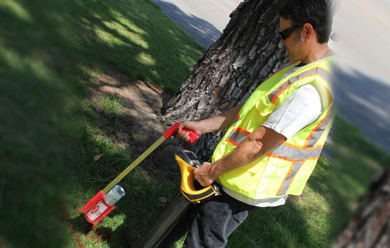
util locate man at work

There are so many industrial activities taking place on land. Such actions increase the possibilities of damaging underground utilities, especially if those operations involve drilling or excavation. As a result, most power lines, telephone cables, gas lines among others are damaged. Damages to these underground connections can result in dire consequences: disrupting critical public services, increase downtime due to repairs and replacements, and catastrophic accidents or death.

As such, when you need to dig, it is essential that you hire utility locating services with experience, knowledgeable personnel, and top-notch equipment such as using advanced ground penetration radar technology in their ground utility surveillance work.

Below is a list of useful tips of alleviating damage to underground pipes and wires.

Call Before Digging

The Federal Communications Commission issued a toll-free number 811 as a Call-Before-You-Dig contact in the U.S. for locating underground public utility lines.

For locating private utility lines, call our committed representatives. They will listen to the details of your project and relay the word to our field technicians who have the technological know-how and equipment to provide utility locating services. Util-Locate company Ground Penetrating Radar (GPR) technology to precisely determine the depth of any in-ground wire and cables with over 97% accuracy.

Nonetheless, it is important to mention that utility markings of underground connections are only done on areas of utility easements, but not on private property. Therefore, any intrusive or drilling activities around a private landholding are not subject to public locating services.

Contact a private utility locating firm such as the Util-Locate company that uses the latest technology to provide precise information about the position and depth of utility lines.

Implementation of Better Working Practices

Several countries have created regulatory policies to govern underground locations to ensure utility damage prevention and maintain safe working conditions. Such policies detail the need to have an excavation plan, reliable utility locating services, and maintaining safety during excavations.

Improving working practices means that these companies need to utilize the latest technology to detect locations of buried pipes and cables. Purchase user-friendly equipment that features updated technological components. The machine must be highly accurate and sensitive, proof against external interference from power lines, multi-frequency Ground Penetration Radar equipment and emphasizing to employees the importance of proper working practices.

Planning of Safe and Efficient Excavation

Safe on sight excavation is a necessary ingredient for all construction works. Accurate information provided before commencing digging or any other civil operation is an essential contribution to safe excavation. Spiking an underground power cable or fracturing a gas pipeline can cause severe property damage and loss of lives from executions or explosions. Knowing their underground presence and exact position help avoid any possibility of property destruction and loss of lives. Using state-of-the-art Ground Penetrating Radar technology reduces unnecessary costs and major inconveniences while enhancing efficient working and site safety.

Protecting and Maintaining Infrastructure

Our company is the most trusted in underground utility damage prevention. Util-Locate company prides in providing a full suite of utility compliance and underground damage prevention throughout Southern California. Our mission is to deliver high quality, safe, efficient, and innovative solutions that safeguard our clients’ infrastructure and critical assets.

Top 3 Things You Should Know About Utility Locating

Utility Making Surveys

For any successful project, utility locating is very essential to avoid costly damages or accidents resulting from digging or excavation. Without proper locating, problems can arise that can be very hard to circumvent. This is why you need a reliable locating service regardless of how small the project is. You cannot rely on line of sight of utility trails. Looking for top-notch utility locating services will ensure that you don’t incidentally come into contact with underground infrastructure. Here are three things you should know about utility locating.

Utility Locating is a damage prevention control prior to excavating/digging.

There are many dangers that exist when you try to dig without proper locating. Underground gas lines pose a safety risk if they are interfered with. Fiber optic lines, water lines, power lines, sewer lines, and other utility lines are very expensive to replace or repair. You don’t want to run into buried lines when digging and cause a major inconvenience. Here at Util-Locate, we give you the confidence to dig knowing that you are safe. We use the latest high-resolution GPR units that guarantee accuracy and helps locate targets in a non-destructive way.

Utility Locating lets you know where your utility services are, which is vital to any pre-design project

Long before you start designing or digging, you can seek utility locating services to establishing the existing mains. This is an essential process that you cannot afford to overlook. No matter the scope of the project, a professional technician will accurately map out the utility locations and their depths. This information will be useful in the placement of structures, trees, foundations, and other necessary demarcations. There are two types of utility lines: private and public utility. For public utilities, you can call 811 for a free locating service. Despite this, only 33% of DIY homeowners call 811 for a free utility locating service. Calling a private utility locating company to mark utility lines is more often the better option. This is because not all utilities are owned publicly and or constitute public utilities. To avoid incidental damage to underground utilities, you will need utility locating done by experienced technicians with the proper tools for the job. Read more underground pipe locator services.

Utility Locating not only saves thousands in damages but lives

We all know how costly and labor intensive it can be to have to replace or repair damaged water lines, sewer lines and other infrastructure. Worse still, there exists the danger of electrocution in the case of cut power lines and dangerous explosions if a gas pipe is interfered with. This can lead to injury and loss of many lives, and cause property destruction worth a lot more money. Our highly trained utility locators are not only focused on damage prevention but also in ensuring no life is lost because of an avoidable mistake.

A single call can save you thousands of dollars and prevent disaster from occurring. We use state-of-the-art technology to improve accuracy and give you peace of mind for all your excavation and digging projects.

3 Underground Utility Locating Equipment You Should Know

3 Underground Utility Locating Equipment You Should Know

Utility locating not only requires years of experience, but you also need the right tools or equipment to do it successfully. This is true whether you’re a beginner or a veteran searching for utility locations before you dig.

While you’ll probably hire professional utility locators to unearth buried utilities for you, it’s still worth learning about the tools they commonly use to detect utility lines. That’s why we’ve broken down the three basic types of utility locating equipment below!

To truly understand what happens during utility location, take the time to read about magnetic locators, pipe locators, and cable locators that utility companies use.

1. Magnetic Locators

Locating a single point, such as a rebar corner pin or a water pipe, is the primary function of a magnetic locator. Its name refers to its ability to detect objects in underground facilities that would attract magnets.

A magnetic locator is sensitive enough to find even a single ferrous object like steel property pins, manhole lids, and water or gas valves. However, magnetic locators are not recommended for locating underground utilities; rather, a pipe and cable locator should be used for this purpose.

2. Pipe Locators

During utility location, detecting buried pipelines can be a real headache when you don’t have a pipe locator. This nifty tool locates pipes by emitting an electromagnetic frequency that travels through the earth.

That frequency would then ricochet off of any pipelines or similar materials that might be buried underneath. The device is usually attached to the main water valve or hydrant and is used to trace water lines before digging or excavation begins.

3. Cable Locators

Similar to a pipe locator in terms of function, a cable locator is a utility device used to pinpoint the exact location of underground cables or signal lines before you dig.

To estimate the location of subsurface lines and cables, the device also emits electromagnetic frequencies. Most cable locators can be utilized for both direct-connect or inductive-coupling approaches.

Frequently Asked Questions

Is there anything about utility locating services that you don’t understand yet? Just in case, we took the time to answer some questions that you may have. Check them out below:

What is underground utility line locating?

This is the process of finding and marking the locations of underground public or private utilities.

How much is private utility locating?

It depends on how large or complex the location is. Private homeowners may pay a few hundred dollars. For larger facilities, though, the costs might reach thousands of dollars.

What is Ground Penetrating Radar?

GPR equipment is used to search for objects under surfaces like concrete and asphalt through the use of radio waves. It’s preferred by many as it’s a non-destructive method. 

Get Professional Services For Locating Underground Utilities

With years of experience and state-of-the-art technology, you can rely on Util-Locate for your utility locating and mapping needs.

Learn how we can help you when you email us at info@util-locate.com or contact us at 1 (866) 638-1075 today!

Why Your Commercial Complex Needs a CCTV Drain Survey Now

Why Your Commercial Complex Needs a CCTV Drain Survey Now

CCTV is a brilliant way to survey the condition of your pipes and entire drainage system. With the use of camera systems, it can help find many types of plumbing problems like a blockage from debris buildup or worrying drain damage.

For anyone managing or running a business unit or building, an annual or regular drainage report can help you understand what state your pipes are in and if any damage has occurred. The drain survey service provided by Util-Locate is prompt and affordable and will help you keep your building in great shape.

Keep reading to find out more about CCTV drain surveys and how they can benefit your property and its drainage system.

What is a CCTV Drain Survey?

A CCTV drain survey is a very thorough drain inspection that uses state-of-the-art camera technology to show what is happening throughout your commercial property’s pipes and drains. These CCTV cameras are led through the pipe system to get a proper handle of any drainage issue even in the narrowest areas.

This type of drain survey is more in-depth than other methods and provides an efficient way for plumbing professionals to understand what problem might be occurring in your drain system. A CCTV survey is also very cost effective so that you can stay within your normal maintenance and repairs budget.

The CCTV camera is hooked up to a monitor or phone and sends a live feed of the pipes as it goes through the drainage system. Contractors and the plumbing team on the site will be able to advise you on what was discovered during the inspection and a repair plan if any issues or damage is discovered.

Why Would I Need a CCTV Drain Survey?

Drain surveys are especially useful for commercial complexes where there are often much larger drainage systems and regular drain surveys are required for proper upkeep. What’s more, such surveys will allow plumbers and contractors to locate and report any problem quickly, which means the right solution will be implemented as soon as possible.

Whether you are a building manager or owner, you likely know how common drainage issues can be. By scheduling a CCTV drain survey, you will be taking an important preventative step to ensure that no drainage issue causes long-term damage.

When are CCTV Drain Surveys Needed?

For commercial properties, it is advisable that CCTV surveys should be regularly scheduled. Typically, this means either annually or twice a year, depending on the volume of usage on the pipes and drains.

That said, your drainage issue might be severe and require immediate response. If you are experiencing any of these sewer and drainage issues, be sure to seek help immediately:

Regular Blockages

This is one of the most common reasons why a drainage survey is required. It will help your contractor if they know the exact location of the blockage in the pipe before they can clear it and return your pipes to working order. Leaving a blockage in your drainage system can result in more blockages developing and damage to the sewers.

Subsidence

Some locations are more prone to subsidence and ground movement. If you are concerned that your commercial complex may be experiencing signs of subsidence, it is very important to have a a CCTV drain survey carried out for a full evaluation of your property’s drains. Subsidence can cause major problems down the line and it is very important to ensure the drain’s condition is solid.

Leaks

If the building experiences regular leaks or clean or waste water, it is definitely a time to call us for a CCTV survey. There could be a tree root infestation in your drains or poorly connected pipes that need to be repaired or replaced. Leaving your pipes in this condition can result in damage that affects the building’s entire drain system.

A CCTV survey for your drainage system is the quickest and most affordable way to diagnose the problem.

Whether it is build-up or a problem with the building structure, our professional team works with top-of-the-range cameras and technology will be able to find the solution to your problem.

Book an Expert Team

When it comes to CCTV drain surveys, they should only be handled with experts who have access to the best tools and equipment. At Util-Locate, we take solving all of our customers’ drain problems very seriously.

We also have the expertise and experience required to ensure your drains and pipes are left in the best state and condition following a drainage survey and any of our services.

Our team has all the required training to use top quality equipment and cameras, which allow us to make the most accurate drainage surveys and project reports. If you are experiencing a drain problem, our experts will be able to solve it with brilliant customer service.

Alongside our utility locating services, we can perform CCTV surveys to discover all the details of your drains. For a menu and description of every service we offer, take a look at our website. You can also request a quote for one of our services, including surveys.

For more information about the services we provide and how CCTV drain surveys can benefit all aspects of your commercial complex and unit plumbing system, don’t hesitate to contact us.

We also offer a 24/7 emergency drain service if you experience an emergency on your property. Simply call us at the Util-Locate emergency number at 1 (866) 638-1075.

What Exactly is GPR and Why Do I Need It?

What Exactly is GPR and Why Do I Need It?

Digging up the ground is so much work and takes so much time. Locating where utilities and structures are underground before digging would make the excavation so much easier.

This is why utility locators, construction companies, and archeologists use Ground Penetrating Radar technology.

Ground penetrating radar technology, commonly known as GPR, is a method of capturing images underneath the ground through the use of electromagnetic energy. As such, GPR technology makes subsurface mapping and locating objects so much easier.

These services have many advantages, from reducing time and effort in locating any object underground to minimizing possible accidents from damaged utility lines.

How Does GPR Work?

A ground penetrating radar uses a transmitter to send signals in the form of radio waves in the 1 to 1000 MHz frequency range into the soil, concrete, or another material.

When these signals hit any object in the soil or concrete, they bounce back, reflecting, refracting, and scattering. It uses an antenna to receive and record these reflected signals, and from there the device calculates the depth and position of an object under the ground.

Aside from measuring depth and location, a ground penetrating radar GPR can also detect material property, size, and shape. This makes generating 2D or even 3D images of objects possible.

Advantages of Ground Penetrating Radar Technologies

As mentioned earlier on in the article, such imaging technologies can detect a wide range of materials buried beneath the surface without damaging the surface.

Compared to calling 811 or using old utility maps, this type of radar can help determine where utility lines are right when you need to know it. It therefore helps eliminate the need for additional allowances in distance due to human error or movement in utility positions due to temperature changes.

Unlike other methods of subsurface mapping, GPR can characterize subsurface properties and identify what kinds of compounds are underground in any given infrastructure. It does so by gathering a wide set of data which makes subsurface geo-referencing possible.

What’s more, GPR’s real-time data features means it’s useful for detecting forgotten or undiscovered items, underground facilities, and other types of surveys.

Utility Mapping Applications

This imaging method can find variances in the return signals caused by different electric charges depending on the substance detected. These services are especially useful for mapping structures since excavators can accurately plan around whatever is underneath the ground.

Such data is then used by excavators to avoid digging accidents, or even by archaeologists to dig up promising artifacts.

GPR, detects metal and nonmetal materials such as plastic, concrete, wood, stone, etc. This makes it useful for detecting electric wires and cables, gas and water pipes, as well as tree roots, stone slabs, and man-made underground fixtures or architecture.

How to Make GPR Data as Accurate as Possible

While there are tons of advantages to using a ground penetrating radar, such services work best under certain environmental factors. To get the most accurate, real-time data from ground penetrating radar services, make sure that these factors are in place.

Soil Properties

One of the conditions needed for GPR to work well is for the surface to be relatively flat; this is necessary to ensure optimum penetration of electromagnetic energy which also results in the most accurate subsurface detection. This means GPR works really well on concrete as opposed to uneven terrain.

Because GPR relies on materials reflecting or refracting signal, anything different from the scanned material can obstruct the reading of the device and limit its extensive scanning capacity.

Depth

Another factor to consider when using GPR is the depth of the object or utility you’re trying to locate. Soil is naturally resistant to electricity; this makes scanning objects more and more difficult the deeper it goes into the ground. Depending on the capacity of the device, one may or may not penetrate as deep as 30 meters or 100 feet deep into the ground.

Water Content

The presence of water in the soil or any material found by GPR will also affect how well electromagnetic energy penetrates it because of dielectric permittivity. Dielectric permittivity refers to how conductive the soil or any surface is, which impacts how a GPR device receives the reflected or refracted signal it sends out.

What Is the Difference Between GPR and Seismic Reflection?

Though GPR and Seismic reflection both try to understand subsurface structures or characteristics, GPR uses electromagnetic energy in the form of radio waves whereas seismic reflection uses acoustic energy in the form of seismic waves.

GPR sends out high-frequency radio waves to detect changes in the electrical properties of a surface. Such changes exist when there’s an object made of a different substance than soil or concrete, as scanning can usually detect the varying electrical properties.

Meanwhile, seismic reflections rely on seismic waves hitting things or surfaces and reflecting back. A seismic device then records the surface’s elastic properties and density, both of which impact the signal reflected back.

Because they scan subsurface characteristics differently, GPR is best used for detecting things like artifacts and utilities whereas seismic reflection is best used to map flat surfaces.

Hiring a Professional Team

Ground penetrating radar equipment can cost anywhere from $15,000 to $50,000. This is a hefty investment for a homeowner in need of some utility mapping for a digging project. While you can rent a device for around $1,000 to $2,000 a day, that’s still impractical especially when you are not used to using it and interpreting the data it gives.

The accuracy of any GPR process relies heavily on who uses it. Using GPR incorrectly can lead to a false interpretation which undermines the purpose of utility mapping to begin with.

If your infrastructure project needs scanning and locating expertise, contact Util-Locate! Our team is made up of trained professionals who use GPR to expose all underground utilities for the most efficient utility locating and mapping services. For any questions about utility surveys or penetration projects, call us today!